Land Use Bylaw
No. 2323
June 2024
Table of Contents
PART I Purpose & Definitions
PART II Administrative Agencies
PART III Development Permit Application
PART IV Development Appeals
PART V Contravention & Enforcement
PART VI Amendments
PART VII General Land Use Regulations
- Subdivision of Land
- Dwelling Units on a Parcel
- Non-Conforming Buildings and Uses
- Exposure Hazards
- Development in the Rural Fringe
- Development Adjacent to Rural Intersections
- Development Near the Airport
- Floodplain Development
- Development Near Water
- Topographic Features
- Design and Siting of Development
- Rural Residential Subdivisions
- Accessory Buildings
- Home Occupations
- Bed and Breakfast Establishments
- Manufactured Homes
- Relocation of Buildings
- Drainage
- Signs
- Shelterbelts and Fences
- Agricultural Operations
- Industrial and Commercial Development
- Parking
- Physical Environment
- Wind Energy Conversion Systems (WECS)
PART VIII Land Use Districts
- Solar Energy Systems
- Districts
- District Boundaries
- “AD” – Agricultural District
- “UF” – Urban Fringe District
- “CR” – Country Residential District
- “RB/I” – Rural Business Industrial District
- “LD” – Lake District
- “R”- Hamlet Residential District
- “HC” – Hamlet Commercial District
- “HM” – Hamlet Industrial District
- “HPI” – Hamlet Public/ Institutional District
- “HR” – Hamlet Reserve District
- “RSH” – Rural Small Holding District
- “DC” – Direct Control District
- “R(ASP)DC” – Rosyth (Area Structure Plan) Direct Control District
- “”CWE” – Commercial Wind Energy District
- “”CSE” – Commercial Solar Energy District
PART VIIII Land Use District Maps
PART I
Purpose and Definition
1.Purpose
The purpose of this Bylaw is to regulate and control the use and development of land and buildings within the municipality to facilitate the orderly and economic development of the Municipal District of Provost No. 52.
2. Definitions
In this Bylaw:
(1) ACCESSORY BUILDING or USE means a building or use, separate and subordinate to the principal building or use.
(2) ACT means the Municipal Government Act, R.S.A. 2000, Ch. M-26, as amended.
(3) AGRICULTURAL LAND means land on which agriculture:
(a) is either a permitted or discretionary use pursuant to this Bylaw; or
(b) is permitted pursuant to the Municipal Government Act.
(4) AGRICULTURAL OPERATION means an agricultural activity conducted on agricultural land for gain or reward, or in the hope of gain or reward, and includes:
(a) the cultivation of land,
(b) the raising of livestock, including game-production animals within the meaning of the Livestock Industry Diversification Act and poultry,
(c) the raising of fur-bearing animals, pheasants, or fish,
(d) the production of agricultural field crops,
(e) the production of fruit, vegetables, sod, trees, shrubs, and other specialty horticultural crops,
(f) the production of eggs and milk,
(g) the production of honey,
(h) the operation of agricultural machinery and equipment, including irrigation pumps, and
(i) the application of fertilizers, manure, insecticides, pesticides, fungicides, and herbicides, including application by ground and aerial spraying, for agricultural purposes.
(5) AGRI-TOURISM OPERATION means the use of land and / or buildings for activities that combine tourism and agriculture, and for which a fee is normally charged. Agri-tourism operations may include, but are not limited to, country vacations, farm tours, market gardens, and trail riding.
(6) AIRPORT means an area of land or water, including the frozen surface thereof, or other supporting surfaces used or intended to be used either in whole or in part for the arrival and departure or servicing of aircraft and includes any building, installation, or equipment in connection therewith for which an airport license has been issued by the Ministry of Transport.
(7) AIRPORT ZONING REFERENCE POINT ELEVATION, in the case of airports, means 662.6 metres (2,173.9 ft) above sea level and is used to determine the outer surface.
(8) APPROACH SURFACE (see TAKE-OFF / APPROACH SURFACE)
(9) BASIC STRIP, in the case of airports, means a rectangular area measured as 75 metres (250 ft.) on each side of the centre line of the runaway and with a total length of 1526 metres (5035 ft.).
(10) BED AND BREAKFAST ESTABLISHMENT means a lodging facility within an owner- occupied dwelling that complies with the Alberta Building Code’s definition of a “Boarding and Lodging House”.
(11) BENCH means a plateau or level (slope typically between land 15%) occurring between the brink of one slope and the toe of another.
(12) BRINK OF SLOPE means the point where a slope begins to fall off steeper than 20%.
(13) CONFINED FEEDING OPERATION means an activity on land that is fenced or enclosed or within buildings where livestock are confined for the purpose of growing, sustaining, finishing, or breeding by means other than grazing, but does not include seasonal feeding and bedding sites.
(14) CORNER PARCEL means a parcel having frontage on two streets at their intersection.
(15) COTTAGE means a one family dwelling not intended for year-round occupation and is associated primarily with recreational or leisure use.
(16) COUNCIL means the Council of the Municipal District of Provost No. 52.
(17) COUNTRY RESIDENTIAL means a detached dwelling or manufactured home situated on a parcel of land used principally for private residential purposes within an otherwise rural or agricultural area.
(18) DEVELOPMENT means:
(a) an excavation or stockpile and the creation of either of them;
(b) a building, or an addition, replacement, or repair of a building;
(c) a change of use of land or a building; or
(d) a change in the intensity of use of land or a building.
Development includes shelter belts and improvements or additions to existing buildings.
(19) DEVELOPMENT OFFICER means a person appointed to the position of Development Officer by resolution of Council, pursuant to this Bylaw.
(20) DEVELOPMENT PERMIT means a document authorizing a development issued pursuant to this Bylaw.
(21) DISCRETIONARY USE means the use of land or a building which is considered on its individual merits and circumstances by the Development Authority and for which a development permit may or may not be issued at the discretion of the Development Authority.
(22) DWELLING, DUPLEX means a building, other than a manufactured home, that consists of two dwelling units sharing a common wall and located side by side or one above the other, and each unit has a separate entrance to grade level.
(23) DWELLING, DETACHED means a building, other than a manufactured home, that consists of one dwelling unit.
(24) DWELLING UNIT means self-contained living premises with sleeping, cooking and sanitation facilities, and intended as a permanent residence.
(25) ESCARPMENT means a valley wall, typically up to 90 m (300 feet) high.
(26) EXTENSIVE AGRICULTURE means the cultivation of land and raising of livestock, but does not include confined feeding operations, as defined by the Agricultural Operation Practices Act. Extensive agriculture does not include the farmstead, residences, and accessory buildings.
(27) FARMSTEAD means improvements used for extensive agriculture (barns, corrals, grain bins, etc.), situated on land for use with such operations. The term “farmstead” does not include the residences, whether they are detached dwellings or manufactured homes.
(28) FLOODPLAIN means land calculated or determined to be located within the 1:100-year floodplain risk area or a water course, as defined by Alberta Environment.
(29) FLOOR AREA means the total floor area of every room and passageway contained in a building, not including the floor areas of basements, attached garages, sheds, open porches, patios, open decks, verandahs or breezeways.
(30) FRONT YARD means a yard extending across the full width of a parcel from the front line of the parcel to the front wall of the main building situated on the parcel and the front yard, where the parcel is a corner parcel fronting onto two roads, shall be decided by the Development Authority.
(31) HEAVY TRUCK AND EQUIPMENT STORAGE means the on-lot storage of heavy trucks and equipment owned and operated by those residing on the lot.
(32) HEIGHT means the highest point of the roof above grade level, when used with reference to buildings and structures.
(33) HEIGHT OF SLOPE means the point where a slope begins to rise steeper than 20%.
(34) HOME OCCUPATION means any trade, business, profession, or occupation carried out in a dwelling unit or accessory building, which is secondary to the primary use. Home occupations do not include the employment of individuals who reside outside of the residence of the owner-occupier. Home occupations do not include hobbies.
(35) INSTITUTIONAL AND PUBLIC USE means a building, structure or parcel used for services that are owned or operated by a public/private institution or a municipal, provincial or federal corporation which provides services for the public or its members (i.e. churches, schools, cemeteries, etc.)
(36) LANE means a public roadway usually less than 10 metres (32.8 ft) wide providing secondary access to one or more parcels.
(37) LIVESTOCK means cattle, horse, sheep, goats, swine, or fowl and other types of agricultural animals.
(38) MANUFACTURED HOME means a structure whether ordinarily equipped with wheels or not, that is manufactured to be moved from one point to another by being towed or carried, and which provides year-round living accommodation for one or more persons and can be connected to utilities.
(39) MUNICIPAL PLANNING COMMISSION means the Municipal Planning Commission established by Council pursuant to the Municipal Government Act.
(40) MUNICIPALITY means the Municipal District of Provost No. 52.
(41) NATURAL RESOURCE EXTRACTIVE INDUSTRY means those uses which are related to natural resource development and include, but are not limited to the following: oil, sulphate, coal, gas, gravel.
(42) NON-CONFORMING BUILDING means a building:
(a) that is lawfully constructed or lawfully under construction at the date this Bylaw or any amendment thereof affecting the building is passed, and
(b) that on the date this Bylaw or any amendment thereof becomes effective does not, or when constructed will not, comply with this Bylaw.
(43) NON-CONFORMING USE means a lawful specific use:
(a) being made of land or a building or intended to be made of a building lawfully under construction, at the date this Bylaw or any amendment thereof affecting the land or building becomes effective, and
(b) that on the date this Bylaw or any amendment thereof becomes effective does not, or in the case of a building under construction will not, comply with this Bylaw.
(44) OUTER SURFACE, in the case of airports, means an imaginary common plane established at a constant elevation of 45 metres (150 ft.) above the airport zoning reference point elevation and extending to the boundary of the “AV” – Airport Vicinity District and the “AF” – Airport Fringe District.
(45) PARCEL means the aggregate of the one or more areas of land described in a certificate of title or described in a certificate of title by reference to a plan filed or registered in a land title office.
(46) PERMITTED USE means the use of land or a building for which a development permit shall be issued provided the proposed development conforms with all regulations of this Bylaw.
(47) PRINCIPAL BUILDING means a building in which is conducted the main or principal use of the site on which it is erected.
(48) PRINCIPAL USE means the main purpose for which a parcel is used.
(49) PROTRUSION means the projection of the brink of an escarpment slope by at least 30 m (100 ft) into a valley.
(50) REAR YARD means a yard extending across the full width of the parcel from the rear wall of the main building situated on the parcel to the rear line of the parcel.
(51) RURAL SMALL HOLDING means a non-agricultural lot within an extensive agricultural quarter section intended to provide sufficient land, and separation from neighbours as well as the adjacent urban area, to accommodate a detached dwelling or manufactured home, related on-site services, vehicle garage, and shop(s)/yard space for heavy truck and equipment storage as a subordinate use.
(52) SEASONAL FEEDING AND BEDDING SITE means an over-wintering site where livestock are fed and sheltered.
(53) SIDE YARD means a yard extending from the front wall of the main building situated on a parcel to the rear wall of the main building and lying between the side line of the parcel and the side wall of the main building.
(54) SIGN means a device or structure for providing direction or providing information or calling attention to such things as a development, business, produce, service, location, object, event, or person.
(55) SITE means:
(a) a quarter section; or
(b) a river lot or settlement lot shown on an official plan referred to in the Surveys Act that is filed or lodged in the Land Titles Office; or
(c) a part of a parcel where the boundaries of the parcel are separately described in a certificate of titles other than by reference to a legal subdivision; or
(d) a part of a parcel where the boundaries of the part of described in a certificate of title by reference to a plan of subdivision.
(56) SUBDIVISION AND DEVELOPMENT APPEAL BOARD means a subdivision and development appeal board appointed pursuant to the Municipal Government Act.
(57) SUBDIVISION APPROVAL AUTHORITY means an agency or individual appointed by Council by Bylaw to review and decide on subdivision applications.
(58) TAKE-OFF / APPROACH SURFACE, in the case of airports, means an imaginary surface consisting of an inclined plane:
(a) the commencement of which coincides with the end of the basic strip;
(b) that rises at a slop ratio of 1:40 (2.5%) measured from the end of the basic strip;
(c) that diverges outward on each side as it rises, at a rate of 10% measured from the respective projected sides of the basic strip; and
(d) that ends at its intersection with the outer surface.
(59) TEMPORARY means a period of time up to one (1) year.
(60) TRANSITIONAL SURFACE, in the case of airports, means an imaginary surface consisting of an inclined plane that:
(a) commences at and abuts the sides of the basic strip;
(b) rises at a slope ratio of 1:7 (14.3%) from an elevation at the centre point of the runway opposite the proposed development, and measured from the sides of the basic strip; and
(c) ends at its intersection with the outer surface and the take-off / approach surfaces.
(61) UTILITIES mean any one or more of the following:
(a) systems for the distribution of gas, whether artificial or natural;
(b) facilities for the storage, transmission, treatment, distribution, or supply of water;
(c) facilities for the collection, treatment, movement, or disposal of sanitary sewage;
(d) storm sewer drainage facilities;
(e) systems for electrical distribution and lighting;
(f) systems for telephone and cable TV distribution.
(62) All other words and phrases mean the same as they do in the Municipal Government Act.
PART II
Administrative Agencies
3. Development Authority
(1) The Development Authority is hereby established for the purpose of exercising development powers and duties on behalf of the Municipality.
(2) The Development Authority is:
(a) any Development Officer while carrying out his or her functions or duties under this Bylaw or the Municipal Government Act; or
(b) the Municipal Planning Commission while exercising development powers or duties under this Bylaw or the Municipal Government Act.
4. Development Officer
(1) The position of Development Officer is hereby established and shall be filled by a person or persons appointed by resolution of Council.
(2) The Development Officer shall perform such duties as specified in this Bylaw and shall:
(a) keep and maintain a copy of this Bylaw and all amendments thereto for inspection of the public during regular office hours;
(b) keep a register of all applications for development, including the decision thereon and the reasons therefore;
(c) receive, consider, and decide on those applications for a development permit for those uses listed as Permitted Uses in the Land Use District, and which comply with the minimum standards for that district;
(d) refer to the Municipal Planning Commission, those applications for a development permit for those uses listed as Permitted Uses in the Land Use District, and which do not comply with the minimum standards for that district;
(e) refer, at his/her discretion, a permit application for any development to those authorities (regional, provincial, or federal) whose interest or jurisdiction may be affected by the application;
(f) refer, with his/her recommendations, to the Municipal Planning Commission for its consideration and decision, applications for a development permit for those uses listed as Discretionary Uses in the Land Use District;
(g) refer to the Municipal Planning Commission, for its consideration and decision, applications for a development permit within the Airport Vicinity Protection Area;
(h) refer to the Municipal Planning Commission any application for a development permit which in his/her opinion should be decided by the Municipal Planning Commission.
5. Municipal Planning Commission
(1) The Municipal Planning Commission is hereby established and shall be filled by persons appointed by resolution of Council.
(2) The Municipal Planning Commission shall perform such duties as are specified in this Bylaw, and shall:
(a) receive, consider, and decide on those applications for a development permit for those uses listed as Discretionary Uses in the Land Use District;
(b) decide on any application referred to it by the Development Officer.
(3) No person who is a member of the Subdivision and Development Appeal Board shall be appointed to act as a member of the Municipal Planning Commission.
(4) The Municipal Planning Commission may make orders, decisions, development permits and approvals and issue notices with or without conditions.
PART III
Development Permit Application
6. Control of Development
(1) No development other than that designated in Section 7 shall be undertaken within the municipality unless an application for it has been approved and a development permit has been issued.
7. Development Not Requiring a Development Permit
Development permits are not required for the following, providing they otherwise comply with the provisions of this Bylaw:
(1) The carrying out of works of maintenance or repair to any building, including interior renovations, provided such works do not include structural alterations or major works of renovation that would effect changes in exterior design.
(2) A temporary building, the sole purpose of which is incidental to the erection or alteration of a building for which a development permit has been issued, and which is removed from the site upon completion of construction/alteration.
(3) The construction of one accessory building on a parcel located in a Hamlet or Country Residential (CR) District provided the accessory building is no greater than 3 m by 4 m (10 x 12 ft.) and meets the setback standards of the relevant land use district.
(4) The maintenance and repair of public works, services and utilities carried out by or on behalf of Federal, Provincial, Municipal, or public authorities on land which is publicly owned or controlled.
(5) The construction, maintenance and repair of private walkways, pathways, driveways, and other similar works.
(6) The erection or construction of solid or non-wire fences, gates, walls, shelter belts and other means of enclosure, subject to the setback requirements outlined in the General Land Use Regulations.
(7) The erection of wire fences, or other fence structures that do not limit visibility, at the discretion of the Development Officer, do not require a permit and shall be exempt from the setback provisions of this Bylaw.
(8) The erection and construction of decks attached to residential buildings, subject to the restrictions outlined in the General Land Use Regulations and to the setback restrictions outlined in the relevant Land Use District.
(9) Extensive agricultural operations (except in the Airport Vicinity Protection Area where development permits are required).
(10) Farmsteads, except in the Airport Vicinity Protection Area as shown on map 13 where development permits are required. (Residences, detached dwellings, or manufactured homes, ARE required to obtain a development permit.)
(11) The use of a building or part thereof as a temporary polling station for a Federal, Provincial, or Municipal election, referendum, or plebiscite.
(12) The completion of a development that would be prohibited by this Bylaw, but was lawfully begun on or before the date of the first official notice (Section 692 of the Act) of this Bylaw provided the development:
(a) is completed within 12 months of the notice; and
(b) complies with any development permit issued for it.
(13) The use of building mentioned in subsection (12) for the purpose for which construction was started.
8. Application for a Development Permit
(1) An application for development permit shall be made to the Development Officer in writing, and shall be accompanied by:
(a) a site plan showing the legal description and the front, rear and side yards if any, and any provision for off-street vehicle parking, and entry and exit points to and from the site;
(b) floor plans and elevations and sections of any proposed buildings;
(c) any other reasonable information that the Development Officer/Municipal Planning Commission deems is necessary to render a decision on the application;
(d) a development permit fee as established by resolution of Council.
(2) Prior to accepting an application for a development permit, the Development Authority may require the applicant to conduct a public meeting.
(3) In making a decision, the Development Authority may:
(a) approve the application unconditionally, or impose conditions considered appropriate;
(b) approve the permit permanently or for a limited period of time;
(c) refuse the permit application, stating reasons for the refusal.
(4) In the case where a proposed specific use of land or a building is not provided for in any land use district in this Bylaw, the Development Authority may determine that the use is similar in character and purpose to another use of land or building that is included in the list of permitted and discretionary uses prescribed for that Land Use District.
(5) In the case where an application for development within a specific district does not comply with the minimum standards for that district, the Development Authority may approve the application provided:
(a) the proposed development would not
(i) unduly interfere with the amenities of the neighbourhood, or
(ii) materially interfere with or affect the use, enjoyment, or value of neighbouring parcels of land, and
(b) the proposed development conforms with the use prescribed for that land or building in this Bylaw.
(6) As part of a development permit application or subdivision application, the Development Authority may request that the applicant enter into a development agreement in accordance with the Municipal Government Act.
(7) An application for a development permit shall, at the option of the applicant, be deemed to be refused when a decision is not made on it by the Development Authority within 40 days after receipt of the application in its complete and final form by the Development Authority.
(8) If a development permit application is refused, the Development Authority need not accept another application for the same or similar use on the same parcel for six months after the date of refusal.
9. Development Permits and Notices
(1) A development permit issued pursuant to this Section for a permitted use where no provisions of this Bylaw have been relaxed or varied, is effective upon the decision being communicated to the applicant.
(2) A permit granted pursuant to this Section for a discretionary use as listed in a Land Use District, does not come into effect until 14 days after the decision is communicated to the applicant.
(3) When an appeal is made pursuant to this Bylaw, a development permit that has been granted shall not come into effect until the appeal has been determined and the permit is affirmed, modified, or nullified thereby.
(4) When a permit has been granted, the Development Authority shall:
(a) In the case of a permitted use where the standards and provisions of this Bylaw have not been relaxed or varied, no notification of adjacent or affected landowners is required.
(b) In all other cases, a notice shall be immediately published in a newspaper circulating in the Municipality stating the location of the property for which the application has been made and the use approved, and a notice in writing may be mailed to the applicant and to all adjacent landowners.
(5) If the development authorized by a permit is not commenced within 12 months from the date of its issue, the permit is deemed to be void, unless an extension to this period is granted by the Development Authority.
(6) A decision by the Development Authority on an application for a development permit shall be given in writing and a copy of it sent to the applicant within 14 days from the date of notice.
(7) When the Development Authority refuses an application for a development permit, the decision shall contain reasons for the refusal.
(8) If, after the issuance of a development permit, it becomes known to the Development Authority that:
(a) the application for a development permit contained a misrepresentation; or
(b) facts have not been disclosed which should have been disclosed at the time of consideration of the application for the development permit; or
(c) the development permit was issued in error
the development permit may be suspended or cancelled by notice in writing, issued by the Development Authority to the applicant to the address given in the development permit application.
PART IV
Development Appeals
10. Appeal Procedure
(1) An appeal may be made to the Subdivision and Development Appeal Board where the Development Authority:
(a) refuses or fails to issue a development permit to a person within 40 days of receiving the application;
(b) issues a development permit subject to conditions;
(c) issues an order pursuant to this Bylaw;
(d) cancels or suspends a development permit pursuant to this Bylaw.
(2) Notwithstanding subsection (1), no appeal is allowed in respect of the issuance of a development permit for a permitted use listed in a Land Use District, unless the provisions of this Bylaw were relaxed, varied, or misinterpreted.
(3) The person applying for a permit or affected by an order, or any other person affected by an order, decision, or development permit, may appeal to the Subdivision and Development Appeal Board.
(4) An appeal shall be made by serving a written notice of appeal, stating the reasons for the appeal, to the Secretary of the Subdivision and Development Appeal Board, within 21 days after the date of the order, decision or permit issued by the Development Authority was either:
(a) received by the applicant, which is deemed to be five (5) days from the date that the decision is mailed, or
(b) first published in a newspaper circulating in the area, for everyone other than the applicant.
11. Public Hearing
(1) Within 30 days of receipt of a notice of appeal, the Subdivision and Development Appeal Board shall hold a public hearing respecting the appeal.
(2) The Subdivision and Development Appeal Board shall give at least 5 days’ notice in writing of the public hearing:
(1) in a newspaper circulating in the area,
(2) to the appellant,
(3) to the Development Authority from whose order, decision or development permit the appeal is the subject of the appeal, and
(4) to those adjacent landowners who were notified by mail and any other person who in the opinion of the Board, is affected by the order, decision, or permit.
(3) The Subdivision and Development Appeal Board shall make available for public inspection before the commencement of the public hearing all relevant documents and materials respecting the appeal including:
(a) the application for the development permit, its refusal, and the appeal therefrom; or
(b) the Order of the Development Authority, as the case may be.
(4) At the public hearing referred to in subsection (1), the Subdivision and Development Appeal Board shall hear:
(a) the appellant or any person acting on his or her behalf;
(b) the Development Authority from whose order, decision or development permit the appeal is made, or a person acting on behalf of the Development Authority;
(c) any other person who was given notice of the hearing and who wishes to be heard, or a person acting on his or her behalf;
(d) any other person who claims to be affected by the order, decision or permit and that the Subdivision and Development Appeal Board agrees to hear, or a person acting on his or her behalf.
12. Decision
(1) The Subdivision and Development Appeal Board shall give its decision in writing together with reasons for that decision, within 15 days of the conclusion of the public hearing.
(2) A decision made under this part of this Bylaw is final and binding on all parties, and subject only to appeal upon a question of jurisdiction or law pursuant to the Municipal Government Act.
PART V
Contravention and Enforcement
13. Contravention
(1) Where a Development Authority finds that a development or use of land or buildings is not in accordance with:
(a) the Municipal Government Act, or the Regulations; or
(b) a development permit or subdivision approval; or
(c) this Land Use Bylaw
the Development Authority may, by notice in writing, order the registered owner, the person in possession of the land or buildings or the person responsible for the contravention, or any or all of them to:
(d) stop the development or use of the land or buildings in whole or in part as directed by the notice,
(e) demolish, remove, or replace the development,
(f) carry out any other actions required by the notice so that the development or use of the land or building complies with the Municipal Government Act, this Bylaw, or regulations under the Municipal Government Act, a development permit, or a subdivision approval,
within the time set out in the notice.
(2) A person who receives a notice pursuant to this Bylaw may appeal to the Subdivision and Development Appeal Board in accordance with the Municipal Government Act and this Bylaw.
14. Enforcement
(1) If a person fails or refuses to comply with an order directed to him or her, the Council or a person appointed by it may, in accordance with the Municipal Government Act, enter on the land or building and take any action necessary to carry out the order.
(2) Where the Council or a person appointed by it carries out an order, the Council shall cause the costs and expenses incurred in carrying out the order to be placed on the tax roll of the parcel of land, and the amount:
(a) is deemed for all purposes to be a tax imposed under the Municipal Government Act from the date that it was added to the tax roll; and
(b) forms a special lien against the parcel of land in favour of the municipality from the date it was added to the tax roll.
PART VI
Amendments
15. Amendments
(1) A person may apply to have this Bylaw amended, by applying in writing and providing reasons in support of the application.
(2) Council may at any time initiate an amendment to this Bylaw by directing the Development Officer to initiate an application, therefore.
(3) An application to amend this Bylaw shall be accompanied by a fee established by resolution of Council. Where an application is considered to be for the greater public interest, Council may waive or refund the established fee.
(4) If an application to amend this Bylaw is refused by Council, then Council need not accept another application for an amendment for the same use of land on the same parcel for a period of six (6) months from the date of the refusal.
(5) All applications to amend this Land Use Bylaw shall be made to Council in writing, and shall be accompanied by the following:
(a) a current photocopy of the title for the property, as it currently exists at the Land Titles Office;
(b) any drawings, plans or maps required by the Development Authority;
(c) a statement of the applicant’s interest in the land;
(d) a statement of the reason for the amendment; and/or
(e) any documents as required by the Development Authority.
(6) All amendments to this Bylaw shall be in conformance with the Municipal Government Act.
PART VII
General Land Use Regulations
16. Subdivision of Land
(1) A development requiring subdivision of land shall not be issued a development permit until such time as subdivision approval has been received from the subdivision approval authority, or upon appeal from the Subdivision and Development Appeal Board or the Land and Property Rights Tribunal.
17. Dwelling Units on a Parcel
(1) No person shall construct or locate or cause to be constructed or located more than one dwelling unit on a lot/parcel, unless:
(a) the second or additional dwellings are contained in the same building designed for or divided into two or more dwelling units (such as a duplex or apartment building), or
(b) the parcel of land is greater than 20 acres and is in the “AD” – Agricultural District.
(2) The Development Authority may issue a permit for a second or additional dwelling unit(s) on a lot/parcel, if in their opinion the proposed development would not:
(a) unduly interfere with the amenities of the neighborhood;
(b) materially interfere with or affect the use, enjoyment, or value of the neighboring properties; and
(c) the proposed development conforms with the use prescribed for that land or building in this Bylaw;
18. Non-Conforming Buildings and Uses
(1) A non-conforming use of land or a building may be continued but if that use is discontinued for a period of six consecutive months or more, any future use of the land or building shall conform with the provisions of the Land Use Bylaw in effect.
(2) A non-conforming use of part of a building may be extended throughout the building but the building, whether or not it is a non-complying building, shall not be enlarged or added to and no structural alterations shall be made thereto or therein.
(3) A non-conforming use of part of a lot shall not be extended or transferred in whole or in part to any other part of the lot and no additional buildings shall be erected upon the lot while the non-conforming use continues.
(4) A non-conforming building may continue to be used but the building shall not be enlarged, added to, rebuilt, or structurally altered except:
(a) as may be necessary to make it a conforming building, or
(b) as the Development Authority considers necessary for the routine maintenance of the building, or
(c) if, at the discretion of the Municipal Planning Commission, the alterations do not increase the extent of non-conformance and are within all other requirements of this Bylaw, the development may be permitted.
(5) If a non-conforming building is damaged or destroyed to the extent of more than 75% of the value of the building above its foundation, the building shall not be repaired or rebuilt except in accordance with the Land Use Bylaw.
(6) The use of land or the use of a building is not affected by reason only of a change of ownership, tenancy or occupancy of the land or building.
19. Exposure Hazards
(1) The location of anhydrous ammonia storage tanks shall be in accordance with the requirements of the Development Authority, who may evaluate such development proposals based on Alberta Environment’s guidelines for the location of stationary bulk ammonia storage facilities.
(2) Flammable liquids storage tanks at bulk fuel plants, service stations or other similar facilities shall be located to the satisfaction of the Development Authority in accordance with the regulations under the Fire Prevention Act.
(3) Setbacks from pipelines and other utility corridors shall be at the discretion of the Development Authority, in accordance with relevant Provincial or Federal Regulations and Acts.
20. Development in the Rural Fringe
(1) The rural fringe area is defined as the area of the Municipality that is within:
(a) 1.6 km (1 mile) of the boundary of the M.D. of Provost No. 52;
(b) 1.6 km (1 mile) of the boundary of the Wainwright Military Camp;
(2) All development permit applications in the rural fringe area will be circulated to the relevant rural municipality for comments and recommendations, prior to a decision being made.
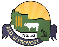
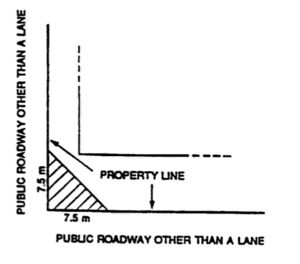
21. Development Adjacent to Roads and Intersections
(1) The minimum development setback from the centre line of a roadway shall be as follows:
(a) 40 m (125 ft) for municipal roads.
(b) As required by Alberta Transportation in the case of provincial highways.
(2) The required development and building setbacks from roadways are included as Figures 1 and 2.
(3) Shelter belts, tree plantings, solid fences, hedges, and other means of enclosure greater than 1 m (3 feet) in height are subject to the setback requirements shown in Figures 1 and 2. Wire fences or other fence structures that do not limit visibility shall be exempt from the setback provisions of this Bylaw.
Figure 1 – Development Restrictions Near an Intersection of Two Rural Roads
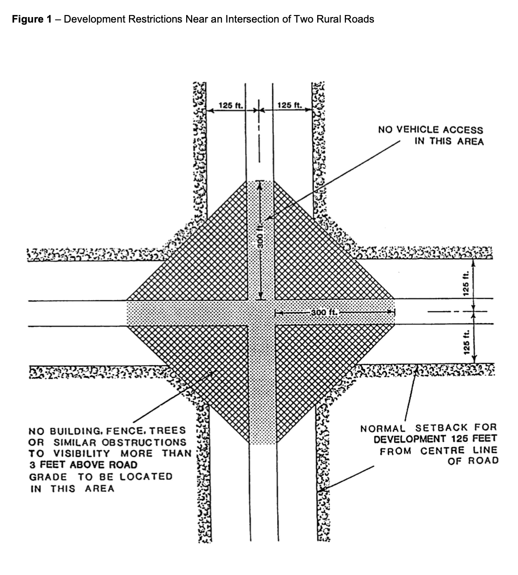
Figure 2 – Development Restrictions Near Roads with a Degree of Curvature Greater than 2 Degrees
22. Development Near the Airport
The following requirements are as illustrated in Figure 3: Development Height Limitations Near Airports and Map 13: Airport Vicinity Protection Area:
(1) The Development Authority may issue a development permit for a development if no point of the development will exceed the height of any of the following surfaces:
(a) the take-off / approach surfaces;
(b) the transitional surfaces; and
(c) the outer surface.
(2) If a development permit application is made for a development whose highest point will penetrate the outer surface, the Development Authority shall send a copy of the application to the Ministry of Municipal Affairs for comment.
(3) Any new development within the Airport Vicinity Protection Area as shown on Map 13 shall not be permitted if, in the opinion of the Development Authority, it generates a large amount of smoke, dust, or attracts birds, or any other use which may be in conflict with the airport.
(4) For the purpose of this Land Use Bylaw:
(a) for the development of railway, the highest point of the development shall be deemed to be 6 metres higher than the actual height of the rails, and
(b) for the development of a roadway or highway, the highest point of the development shall be deemed to be 4 metres higher than the centre line of the roadway.
(5) Any new development within the Airport Vicinity Protection Area shall conform to the exterior acoustic insulation requirements of the Alberta Building Code;
(6) Subdivision of land within the area defined as the Airport Vicinity Protection Area as displayed on Map 13 may not be allowed if, in the opinion of the Municipal Planning Commission, development of the resultant parcels increases the potential for conflict with the airport facilities or if the size of the parcels is not suitable for any of the potential uses in this district.
23. Floodplain Development
(1) Land within 1:100-year floodplain (as determined by the Ministry of Environment and Protected Areas) shall not be developed unless sufficient landfill can be provided to raise the area at least one metre (3 ft) above the flood level, or other suitable flood proofing techniques are employed to the satisfaction of the Development Authority.
- On existing registered lots, development may be permitted within the 1:100-year floodplain provided that:
- the developer or registered owner shall hold the Municipality harmless from any damage to or loss of development caused by flooding;
- all mechanical and electrical equipment is located above the 1:100-year floodplain.
24. Development Near Water
(1) No part of any residential building should be within 40 m (125 ft.) of a river, lake, stream, or other permanent water body, unless otherwise allowed within an approved Area Structure Plan or other statutory document.
(2) Residential development and subdivision adjacent to a water body shall be according to the following:
(a) depth vs. width ratio from the high-water mark shall be 3:1;
(b) provision of non-polluting sewage facilities;
(c) access can be provided from existing developed road rights-of-way;
(d) the parcel may be set back an appropriate distance from the high-water mark in order that public access can be provided through the dedication of Environmental Reserve.
(3) In the case of development permit applications on existing parcels, the Development Authority may relax subsection (1) and (2).
Figure 3 – Development Height Limitations Near Airports
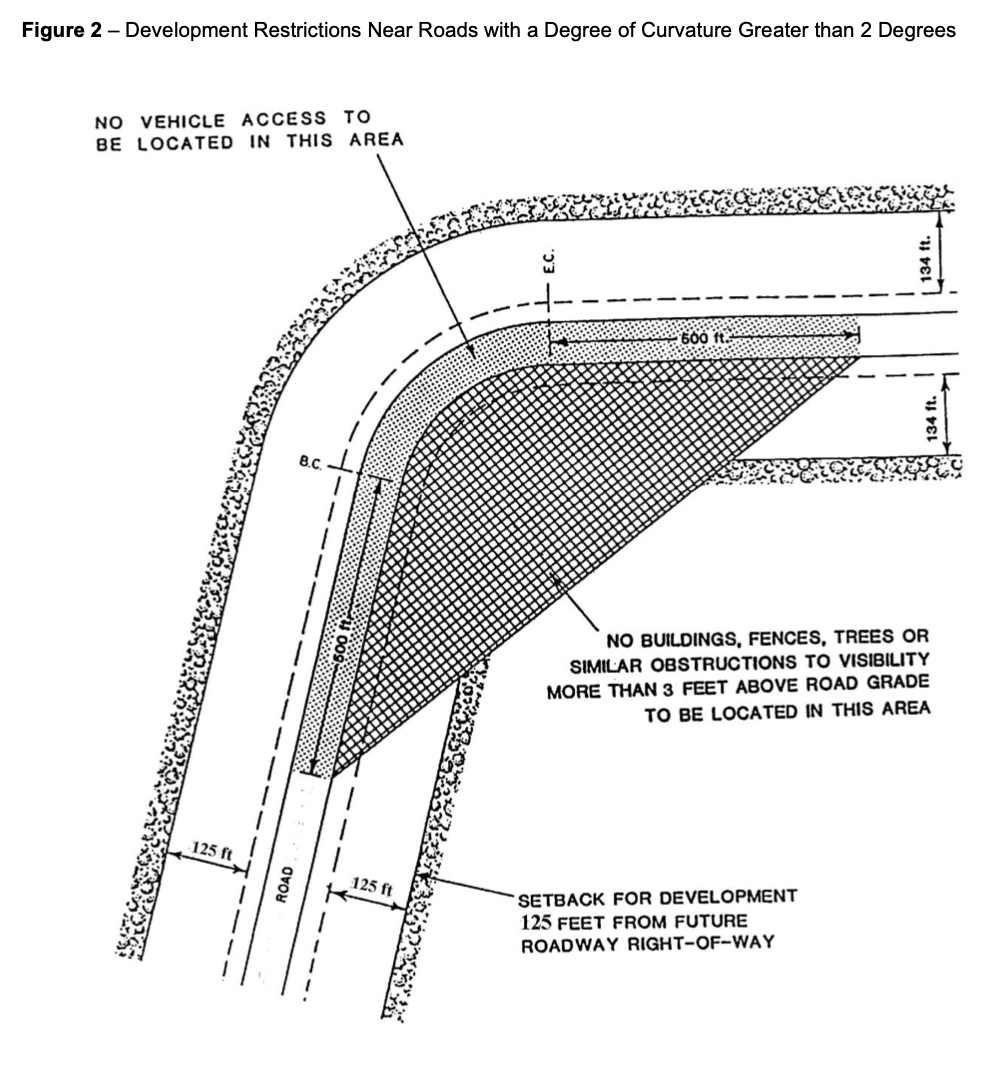
25. Topographic Features
(1) Figure 4 illustrates the terms defined in this subsection.
(2) Isolated features:
(a) For isolated land projections such as hummocks and buttes;
(i) slopes greater than 20% shall not be developed unless otherwise approved by the Development Authority; and
(ii) slopes greater than 15% may require special engineering or other treatment to be developed.
(b) If such isolated features are to be leveled:
(i) the resulting slopes shall not exceed 20%; and
(ii) the contours, leveling, compaction, and other engineering and environmental aspects shall be satisfactory to the Development Authority and other relevant authorities.
(3) Protrusions:
(a) Protrusions wider than 90 m (300 ft) at their widest point shall not be removed.
(b) Removed or leveled protrusions shall result in slopes of no more than 33%.
(4) Minimum Setback Requirement:
No part of any building shall be within the following setbacks, unless otherwise determined by the Development Authority:
(a) Setbacks from toes of slopes
(i) 7.5 m (25 ft) where the slope height is below 9 m (30 ft);
(ii) 23 m (75 ft) where the slope height is between 9 m (30 ft) and 23 m (75 ft);
(iii) 40 m (125 ft) where the slope height exceeds 23 m (75 ft).
(b) Setbacks from brinks of slopes:
(i) equal to the average depth of the valley; or
(ii) a distance which is deemed sufficient by a geotechnical report performed by a professional engineer.
Figure 4 – Topographical Features
26. Design and Siting of Development
(1) All development shall be in general conformity with adjacent developments.
(2) The siting and landscaping of all parcels shall be to the satisfaction of the Development Authority.
(3) In Hamlet Districts, the design, external finish, and architectural appearance of all buildings, including accessory structures and signs, shall be similar to and complement the existing structures on parcels adjacent to the parcel onto which the building/structure is to be located.
27. Rural Residential Subdivisions
(1) Farmstead Separation – Subdivision of an existing farmstead for an unsubdivided quarter section may be allowed provided that:
(a) the dwelling is habitable;
(b) access can be provided without unduly severing the agricultural land;
(c) the minimum of agricultural land is removed from production;
(d) parcel size is kept as small as possible while including buildings, shelterbelts, corrals, wells, and septic systems. Preferably not greater than 10 acres (4.0 ha). Parcel sizes greater than 10 acres will be allowed only to encompass such items as water wells, shelter belts, septic systems, and accessory farm structures.
(2) Country Residential – Undeveloped single country residential parcels may be allowed provided that:
(a) parcel size be kept as small as possible, preferably not less than 2 acres (0.8 ha) and not greater than 5 acres (2.02 ha);
(b) legal and physical access can be provided, subject to any service agreement(s); and
(c) the remnant of the quarter section has access to an opened public road.
(3) Rural residential subdivisions may not be allowed where potential conflicts with adjacent or surrounding agricultural land uses would result.
(4) The Development Authority may consider additional rural residential subdivisions based on the merits of each application.
28. Accessory Buildings
(1) A structure which is attached to the principal building by a roof, a floor or a foundation is considered a part of the principal building.
(2) An accessory building shall be located at least 2 m (6 ft) from any principal building.
(3) An accessory building shall not be used as a dwelling.
(4) The total combined floor area of an accessory building shall not exceed 15% of the site area.
29. Home Occupations
(1) All development permits issued for home occupations shall be revocable at any time by the Development Authority if in their opinion, the use is or has become detrimental to the amenities of the neighbourhood. The process of revocation shall be in accordance with the Municipal Government Act.
(2) The Development Authority may issue a temporary permit for a home occupation.
(3) A home occupation shall not include any use or operations which will cause or create a nuisance by way of undue dust, noise, smell, smoke, or traffic generation.
(4) In hamlets and the “CR” – Country Residential District, a home occupation shall be confined to the residence or accessory buildings and be subordinate to the residential use and shall be limited to those uses which do not interfere with the rights of adjacent residents. The Development Authority may permit limited outside storage, if it is determined, the outside storage will not affect neighbouring properties and can be screened from view.
(5) In hamlets and the “CR” – Country Residential District, signage for a home occupation is restricted to one sign per site attached to the building with a maximum size of 1 m2 (10 sq. ft). Appearance of the sign shall be of a professional quality to the satisfaction of the Development Authority.
(6) In the agricultural districts, a home occupation shall be confined to the residence or farmyard site and subordinate to the principal use of the site for agricultural and residential purposes. Further, in this district, limited outside storage of materials, goods or equipment may be permitted.
30. Bed and Breakfast Establishments
(1) Bed and breakfast establishments shall conform to the following standards as well as the Provincial Building Code:
(a) no cooking facilities in guest room;
(b) minimum room size of 75 sq. ft. (7 m2) per single occupant and 50 sq. ft. (4.6 m2) per person for multiple occupants;
(c) window compulsory for each guest room;
(d) sanitation and potable water as required by Health Unit;
(e) smoke alarms required for each level of buildings; and
(f) portable fire extinguisher required for each level of building.
(2) Off-street parking shall be provided with a minimum of one stall per owner plus one stall per guest room.
(3) Access to a public lane or street shall be to the satisfaction of the Development Authority.
(4) Signing is restricted to one sign per site attached to the building with a maximum size of 1m2 (10 sq. ft.). Appearance of the sign shall be of a professional quality to the satisfaction of the Development Authority.
(5) All development permits issued for bed and breakfast establishments shall be revocable at any time by the Development Authority if in his/her/their opinion, the use is or has become detrimental to the amenities of the neighborhood.
(6) The Development Authority may issue a temporary permit for a bed and breakfast establishment.
31. Manufactured Homes
(1) All manufactured homes shall comply with the Alberta Building Code.
(2) Manufactured homes shall have a foundation capable of supporting the maximum anticipated load of the manufactured home during all seasons without settlement or other movement.
(3) The undercarriage of each manufactured home shall be screened from view by the foundation or by skirting within 30 days of placement of the manufactured home.
(4) All manufactured homes within hamlets shall be serviced by municipal water and sewer services as available.
(5) The Development Authority may request that an application for a manufactured home be accompanied by a recent photograph of the structure, and wherever possible the Development Authority may inspect the structure.
32. Relocation of Buildings
(1) Where a development permit has been granted for the relocation of a building on the same site or from another site, the Development Authority may require the applicant to provide a Performance Bond or a letter of credit to ensure completion of any external renovations set out as a condition of approval of the permit.
(2) All external renovations to a relocated building are to be completed within one year of the issuance of the development permit.
(3) Prior to approving a development permit for a moved in building, the Development Authority may obtain the views in writing of the adjacent registered property owners within a minimum of 60 m (196 ft.).
(4) The Development Authority may request that an application to relocate a building or structure be accompanied by a recent photograph of the building/structure, and wherever possible the Development Authority may inspect the building/structure.
33. Drainage
(1) In all Hamlet, “CR” – Country Residential, and “LD” – Lake Districts, parcels shall be graded in such a manner that all surface water will drain from the building site to the back lane and/or front street. Surface water shall not drain onto adjacent parcels.
(2) The Development Authority may establish parcel and building elevations if it is felt that drainage from existing elevations will affect adjacent parcels.
34. Signs
(1) No sign or sign structure shall be erected without the prior consent of the registered owner and the occupant of the land in question.
(2) No sign or sign structure shall be erected where it may interfere with, obstruct, or be confused with any authorized traffic sign, signal, or device.
(3) No sign or sign structure shall be erected adjacent to a provincial highway without prior approval of Alberta Transportation.
(4) All signs and sign structures shall be kept in a safe and tidy condition or may be required to be renovated or removed by Council.
(5) All signs shall be sited to the satisfaction of the Development Authority.
(6) The following signs may be erected on any land or affixed to the exterior of any building without the need for a development permit.
(a) non-illuminated signs for identification no more than 1m2 (10 sq. ft.) in area, and limited to one per parcel;
(b) non-illuminated signs of local authorities, utility boards or other public or quasi-public bodies.
35. Shelterbelts and Fences
(1) Along provincial highways, shelterbelts, and fences of at least 2 m (6 ft.) in height shall be set back as required by Alberta Transportation.
(2) Shelterbelts and fences of at least 2 m (6 ft.) in height shall be set back 40 m (125 ft.) from the centre line of all municipal roads, unless otherwise approved.
(3) The erection of wire fences, or other fence structures that do not limit visibility are exempt from subsection (2).
(4) Fencing in hamlets shall be constructed from material appropriate for the land use district in which the fence is located and shall be in general conformity with adjacent dwellings.
(5) On corner lots within hamlets, no fence wall, tree, hedge, or other structure, object or plant exceeding 1 m (3 ft) in height shall be permitted in a corner visibility triangle as indicated in Figure 5.
Figure 5 – Development Restrictions for Corner Visibility Protection
36. Agricultural Operations
(1) Agricultural land rated as Canadian Land Inventory (CLI) classes 1 to 4 shall be encouraged to be preserved for agricultural operations.
(2) The creation of parcels less than 160 acres (64.7 ha) on agricultural land may not be permitted unless specifically permitted elsewhere in this Bylaw. When permitted, these parcels should not:
(a) fragment existing efficiently sized farms;
(b) utilize better quality agricultural land.
(3) Written notice may be provided to residents in the Municipality describing the nature of agricultural operations that exist within, or in close proximity to, the Municipality.
37. Industrial and Commercial Development
(1) All industrial and commercial subdivisions or developments should minimize agricultural land being removed from production.
(2) Industrial and commercial uses should not be located and designed to create conflicts with adjacent or surrounding land uses through unsightly appearance, emission of noise or pollutants, creation of dust and similar disturbances.
(3) Industrial and commercial uses shall have adequate sewage disposal systems and available water supplies as approved by the appropriate authorities.
(4) In addition to the development permit application requirements of Part 3 of this Bylaw, applications for development permits for industrial and commercial uses shall include information as outlined in Appendix “A”.
(5) A permanent water license shall be obtained BEFORE construction can begin if a water source is required for the development.
38. Parking
(1) Unless otherwise specified in this Bylaw, parking requirements shall be at the discretion of the Development Authority.
(2) A parking space shall not be less than 15 m2 (160 sq. ft) in area and not less than 2.5m (8 ft.) wide.
39. Physical Environment
(1) The Development Authority may consider the environmental impact of any proposed development. The Development Authority may refer the proposal to a relevant provincial department for comment on the nature of the environmental concern. Where a development is considered to have a significant environmental impact, the Development Authority may request the developer to have an environmental evaluation prepared and submitted by an appropriate professional or undertake its own environmental evaluation regarding the proposed development. All costs associated with an environmental evaluation are the responsibility of the developer.
40. Wind Energy Conversion Systems (WECS)
DEFINITIONS
The following definitions shall apply to this part:
(40.1) BLADE means an element of a WECS rotor which acts as a single airfoil, thereby extracting kinetic energy directly from the wind.
(40.2) BLADE CLEARANCE means the distance from grade to the bottom of the rotor’s arc, in reference to a horizontal axis rotor.
(40.3) COMMENCMENT OF CONSTRUCTION means the moment any excavation has begun for the purposes of this section.
(40.4) HORIZONTAL AXIS ROTOR means a WECS where the rotor is mounted on an axis horizontal to the earth’s surface.
(40.5) POWER PLANT means a WECS used for the generation and gathering of electric energy from a wind source for the purposes of this section.
(40.6) ROTOR’S ARC means the largest circumferential path travelled by the WECS blade.
(40.7) SHADOW OR FLICKER means the repetitive moving shadows or reflection cast from the rotor blades as they pass through the sunlight.
(40.8) TOTAL HEIGHT means the height from grade to the highest vertical extension of the WECS. In the case of a WECS with a horizontal axis rotor, total height includes the distance from grade to the top of the tower, plus the distance from the top of the tower to the highest point of the rotor’s arc.
(40.9) TOWER means the structure that supports the wind turbine above grade.
(40.10) VERTICAL AXIS ROTOR means a WECS where the rotor is mounted on an axis perpendicular to the earth’s surface.
(40.11) VIEWSCAPE means the area visible from a point, a line, an arc, or specific locality that contain historic scenic value as deemed by Council to be worthy of preservation from development.
(40.12) WIND ENERGY CONVERSION SYSTEM – COMMERCIAL means a power plant consisting of one or more wind turbines and related facilities with a rated capacity of greater than 1 megawatt connected to the same substation or metering point used for the production of electrical power primarily for resale. The boundary of a WECS-Commercial development shall be defined by the legal boundaries of all titled parcels where the development has infrastructure proposed or located within.
(40.13) WIND ENERGY CONVERSION SYSTEM – MICROGENERATION means a single power plant consisting of a wind turbine and related facilities with a rated capacity of less than 1 megawatt, and which is intended to primarily provide electrical power for the on-site consumption requirements, either on or off-grid, and may provide residual power to the grid but is not intended to produce power primarily for resale. The boundary of a WECS – Microgeneration shall be the legal boundaries of the titled parcel where the wind turbine is located.
(40.14) WIND TURBINE means the components of a power plant that produce electrical energy and ancillary services including the rotor, generator and tail fixed on a tower.
APPLICATION REQUIREMENTS FOR A WECS
40.15 APPLICATION REQUIREMENTS FOR A WECS – MICROGENERATION
A development permit application for a WECS – Microgeneration shall be accompanied by:
(1) the manufacturer’s information on power generation and tower construction;
(2) appropriate letter of approval from NAV Canada if required;
(3) shadow/ flicker and noise data shall be considered, and acceptable reports completed by an accepted professional in the field may be required if deemed appropriate as determined by Council;
(4) a sound report as measured at the property line of the parcel where the development permit is applied;
(5) scaled drawings of the foundation and tower showing compliance with CSA standards and certified by a professional structural engineer;
(6) an accurate site plan showing and labeling the information including the specific location of the WECS with setbacks from property lines and surrounding buildings within 0.5km;
(7) Any additional information deemed necessary by the development authority to make an informed decision.
40.16 WECS – MICROGENERATION REGULATIONS
A WECS – Microgeneration shall be considered in accordance with the following requirements:
(1) Maximum Tower Height:
(a) Parcel size – 0.2 ha. (0.5 acres) – 0.4 ha. (1.0 acre)
30 m4 ft.)
(b) Parcel size greater than 0.4 ha. (1.0 acre)
40 m (131.2 ft.)
Tower height shall be in accordance with the manufacturer requirements and shall conform to the setback requirements below.
- Setback Requirements:
(a) Setbacks from property lines
The WECS – Microgeneration tower base shall be no closer to the property line than the total height of the WECS – Microgeneration, and no part of the tower structure, including guy wire anchors, may extend closer than 3 m (10 ft.) to the property boundaries of the site. The Development Authority may waive the tower base setback requirements if the adjacent property owner grants an easement for the location of the WECS – Microgeneration to be closer than these requirements.
(b) Setbacks from Structures
(i) Dwellings:
The WECS – Microgeneration tower base shall be no closer to a dwelling unit on an adjacent property than the total height of the WECS – Microgeneration. No variance or relaxation of this requirement is permitted.
(ii) Accessory buildings or structures
No requirements
- Sound
Sound levels from a WECS – Microgeneration shall not negatively impact adjacent property owners. A satisfactory report from a sound engineering professional may be required to ensure noise levels are not above that of normal ambient background noise on adjacent properties. This determination shall be measured at the property line of the parcel in a direct line between the WECS – Microgeneration and the dwelling.
- Viewscape
The nature of a WECS – Microgeneration requires the installation of the turbine on a tall tower, 25-30 ft. above structures or trees, to reach wind conditions and avoid turbulence. Visual Impact concerns shall be considered where there is significant scenic or historical value associated and where there is a clear public benefit.
(5) Finish and Appearance
A WECS – Microgeneration shall be finished in a non-reflective matte and in a colour that minimizes any obtrusive impact to the satisfaction of the MPC.
(6) Advertising
No advertising shall appear on the tower, blades, or turbine.
- Consultation Requirements
Applicants for a WECS – Microgeneration shall be responsible for circulating the proposal prior to application to adjacent property owners using the approved form. Any comments received from the circulation shall be included with the application.
- Decommissioning
If the active production of electricity from a WECS – Microgeneration is discontinued for two years or more the WECS – Microgeneration shall be removed. Upon termination of the use, the entire facility shall be removed, and the site shall be restored to pre-construction condition.
40.17 APPLICATION REQUIREMENTS FOR A WECS – COMMERCIAL
In addition to the development permit application requirements of Part 3 of this Bylaw, applications for development permits for a WECS – Commercial shall include the following information:
(1) A separate WECS – Commercial development permit application shall be submitted for each titled parcel.
(2) An accurate site plan showing and labeling all relevant information including the specific location of each existing and proposed Wind Turbine including setbacks as defined in Section 40 (also to be provided in chart form), all associated substations, collection, and transmission system on or abutting the subject lot or parcel, and contours of the land and access roads for the complete WECS – Commercial.
(3) An accurate plan showing the titled parcels and location of WECS – Commercial in each application.
(4) A digital database listing exact location and base elevation of each wind turbine in a format acceptable to the M.D.
(5) a visual representation depicting the wind farm from:
(a) no further than 5 km (3.1 miles) away;
(b) each accessible residence within 2 km (1.2 miles) of the WECS – Commercial boundaries.
(c) any significant sites as determined by the MPC.
The visual representation shall include scale elevations, photographs of the proposed WECS – Commercial showing tower height, rotor diameter, colour and landscape.
(6) The turbine specifications indicating:
(a) the WECS – Commercial maximum rated output in kilowatts (or megawatts);
(b) safety features and sound characteristics;
(c) type of tower;
(d) dimensions of tower and rotor.
(7) The following analyses:
(a) the potential for noise at the following:
– the base of the tower,
– the parcel boundaries of the development area,
– at any habitable or occupied dwelling within 2 km (1.2 miles) of any WECS – Commercial.
(8) A report regarding any public information meetings or other process conducted by the developer in accordance with Section 40.18(12);
(9) Construction plans and any impacts to M.D. infrastructure including existing roads and development of new roads or approaches to M.D. standards;
(10) Post-construction reclamation plans;
(11) Decommissioning plans including a full annotation of reclamation securities;
(12) The developer to provide copies of appropriate reports, comments and requests for approvals from the following:
(a) Transport Canada
(b) NAV Canada
(c) Alberta Arts, Culture and Status of Women
(d) Alberta Environment
(e) Alberta Transportation
(f) Alberta Sustainable Resource Development
(g) Alberta Public Land, Parks and Recreation;
(h) Alberta Electric Systems Operator (AESO)
(i) STARS
(j) Any other approvals or requirements as determined necessary by the MPC.
40.18 WECS – COMMERCIAL REGULATIONS
(1) Wind Energy Conversion System – Commercial developments shall require reclassification to the Commercial Wind Energy ‘CWE’ Land Use District prior to acceptance of a development permit application.
(2) The applicant shall forward to the M.D. copies of all regulatory and utility permits, approvals, and conditions prior to commencement of construction.
(3) A WECS – Commercial development permit shall have a maximum five (5) year development timeline as outlined below:
(a) Commencement of construction shall occur within two (2) years of the issuance of the development permit. A time extension as described in (c) or a timeline suspension as described in (d) must be applied for prior to the expiration of the two (2) year commencement of construction period;
(b) Construction shall be completed within two (2) years of commencement of construction. The one (1) year time extension described in (c) may be granted by MPC provided it was not previously granted under subsection (a). A time extension as described in (c) or a timeline suspension as described in (d) must be applied for prior to the expiration of the two (2) year construction period;
(c) A time extension considered by MPC in (a) and (b) may be approved for a single one (1) year term and the applicant must provide reasons why the extension is necessary;
(d) The MPC may consider suspending the five (5) year timeline described above where a development hardship is proven to the satisfaction of the MPC. The MPC shall specify the duration of any timeline suspension as part of the approval;
(e) the development permit shall expire if the suspension period in (d) is not granted and any period described in (a), (b), (c), or (d) lapses.
(4) The MPC may require the developer to minimize impacts and nuisance or safety effects:
(a) within 1.6 km (1 mile) of a Provincially controlled highway;
(b) within 2 km (1.2 miles) of a developed Country Residential area, Hamlet, Town, or Village boundary.
A WECS – Commercial development application shall be considered in accordance with the following requirements:
(5) Maximum Tower Height:
Tower height shall be considered in accordance with the manufacturer and technical requirements for maximum efficiency and shall conform to the setback requirements below.
- Minimum Setback Requirements:
(a) Setbacks from property lines
(i) From any Provincial Highway – as per Alberta Transportation
(ii) From any municipal road allowance or property line – Total height plus ten (10) percent.
(iii) Where no road allowance is located between property lines (whether both parcels are included within the same WECS – Commercial development boundary or the adjacent parcel is located outside of the development boundary – in accordance with Section (6)(a)(ii). Minimum setback requirements may be reduced with the agreement of the affected landowner and registration of an easement on the land title of the affected property.
(b) Setbacks from Structures
(i) Dwellings:
A WECS – Commercial tower base setback from a dwelling shall be a minimum distance of 1.6 kilometres (1 mile) unless a lesser distance is agreed to by the owner of the affected dwelling. If a lesser distance is agreed to by the owner of the affected dwelling the minimum setback shall not be less than that determined in accordance with the modeled sound level not exceeding 40dBA measured at a distance of 15m from the nearest or most impacted dwelling , and no closer to a dwelling on an adjacent property than the total height of the WECS – Commercial plus ten (10) percent. No variance or relaxation of this requirement is permitted. Any agreement between the owner of the affected dwelling and the developer shall be provided to the MPC as an attachment to the development permit application.
(ii) Accessory buildings or structures
Setback requirements may be considered by the MPC if necessary to reduce the impact of a WECS – Commercial on other structures.
- Minimum Blade Clearance from grade – 7.5 m (24.6 ft.)
- Tower Access and Safety
To ensure public safety, the MPC shall give consideration to the following:
(i) Climbable Tower – a security fence with a lockable gate shall surround a WECS – Commercial tower not less than 1.8 m (5.9 ft.) in height;
(ii) No ladder or permanent tower access device shall be located less than 3.7 m (12.1 ft.) from grade;
(iii) A locked device shall be installed on the tower to preclude access to the top of the tower.
(iv) All of the above to be required or any such additional safety mechanisms or procedures to be provided as the MPC considers reasonable and appropriate;
(v) Tower of tubular construction with locked internal access will preclude the above requirements.
- Viewscape
The nature of any WECS requires the installation of the turbine on a tall tower to reach the appropriate wind conditions and avoid turbulence. Visual Impact concerns shall be considered where there is significant scenic or historical value associated and where there is a clear public benefit.
(10) Finish and Appearance
A WECS – Commercial tower shall be finished in a non-reflective matte and in a colour that minimizes any obtrusive impact to the satisfaction of the MPC.
(11) Advertising/ Signage
No advertising shall appear on the tower or blades. The turbine may contain the manufacturers and/or owners’ identification only.
- Consultation Requirements
Applicants for a WECS – Commercial development shall be responsible for appropriate public consultation prior to an application submission and shall include:
(i) Public meeting hosted and advertised by either general mail out or newspaper advertising at least two weeks in advance, with the applicant’s contact information provided.
(ii) Adjacent landowners to proposed WECS sites must be notified in writing, with copies of the notice and a landowners list provided with application information.
(iii) Information provided at meeting must address all points required in the development permit application requirements.
(iv) Summary of consultation and feedback to be included with application as requested.
- Transmission and Distribution Lines
All electrical transmission lines used to interconnect the towers and/ or substation facilities shall be underground installation unless otherwise approved by the MPC.
- Repowering
(a) Should a developer propose alteration or repowering of an existing WECS – Commercial development with changes from the original approval a new development permit application shall be required.
(b) If infill development (addition of wind towers) to an existing WECS – Commercial development a new development permit application shall be required.
- Decommissioning
If the active production of electricity from a WECS – Commercial development is discontinued for two years or more the developer shall provide a report to the MPC stating the operations plan for the project. Decommissioning of the WECS – Commercial development may be required. Failure to comply with a decommissioning request from the municipality may result in the issuance of a stop work order by the designated officer in accordance with the provisions of the Municipal Government Act.
41. SOLAR ENERGY SYSTEMS (SES)
DEFINITIONS
The following definitions apply to this part:
(41.1) COMMENCMENT OF CONSTRUCTION means the moment any excavation has begun for the purposes of this section.
(41.2) OPERATOR means, for the purposes of this Bylaw, the holder of a license, approval or permit issued by the Alberta Utilities Commission for the purposes related to an SES and its attendant infrastructure.
(41.5) POWER PLANT means a SES used for the generation and gathering of electric energy from a solar source for the purposes of this section.
(41.6) PROJECT FOOTPRINT means all the lands which are a part of an approved application as well as any residual lands within a titled parcel, whether or not the lands are leased by an operator.
(41.7) SOLAR ENERGY SYSTEM – COMMERCIAL, means a power plant consisting of commercial-scale solar installations with photovoltaic panels and related facilities with a rated capacity of greater than 5 megawatts connected to the same substation or metering point used for the production of electrical power primarily for resale. The boundary of a SES – Commercial development shall be defined by the legal boundaries of all titled parcels where the development has infrastructure proposed or located within.
(41.8) SOLAR ENERGY SYSTEM – MICROGENERATION, is a single power plant consisting of small-scale solar installations with photovoltaic panels and related facilities with a rated capacity of 5 megawatts or less, and which is intended to primarily provide electrical power for the on-site consumption requirements, either on or off-grid, and may provide residual power to the grid but is not intended to produce power primarily for resale. The boundary of a SES – Microgeneration shall be the legal boundaries of the titled parcel where the solar panels and related facilities are located.
(41.9) SOLAR PROJECT means a power plant that produces electrical energy from solar energy that includes solar collectors, solar reflectors, roads, fences, collector lines, inverters, and other related infrastructure.
(41.10) VIEWSCAPE means the area visible from a point, a line, an arc, or specific locality that contain historic scenic value as deemed by Council to be worthy of preservation from development.
APPLICATION REQUIREMENTS FOR A SES
41.11 APPLICATION REQUIREMENTS FOR A SES – MICROGENERATION APPLICATIONS
A development permit application for a SES – Microgeneration shall be accompanied by:
- the manufacturer’s information for system design, installation, and output capacity;
- for roof or wall-mounted panels, the manufacturer’s specification and design drawings for panels mounted to the roof or walls of a building or accessory structure, including how the panels are to be affixed, maximum projection from the roof or wall, and structural capacity of the roof or wall to support the proposed development;
- for free-standing solar panels, a description of the proposed ground mount design and maximum height from the existing grade;
- appropriate letter of approval from NAV Canada if required;
- if located adjacent to a provincial highway, an appropriate approval received from Alberta Transportation;
- glare and noise data shall be considered, and acceptable reports completed by an accepted professional in the field may be required if deemed appropriate as determined by Council;
- a sound report as measured at the property line of the parcel where the development permit is applied;
- scaled drawings of the solar array and attendant facilities showing compliance with CSA standards and certified by a professional structural engineer;
- an accurate site plan showing and labeling the information including the specific location of the SES with setbacks from property lines and surrounding buildings within 0.5km; and
- Any additional information deemed necessary by the development authority to make an informed decision.
41.12 SES – MICROGENERATION REGULATIONS
A SES – Microgeneration shall be considered in accordance with the following requirements:
- Maximum Free-Standing Panel Height
- 2.44 metres (15 feet)
- Maximum Limits for Wall or Roof-Mounted Panels
- Panels mounted to a roof of a building or accessory structure shall not extend beyond the outermost edge of the roof.
- Panels mounted to a roof or wall of a building or accessory structure shall not project more than 0.45 metres (1.5 feet) from the surface.
- Panels shall be located so they do not create a glare on or impact neighbouring parcels or public roadways, or unduly affect the amenities of the neighbourhood, or present a danger to the travelling public.
- The maximum number of panels per parcel shall be regulated by the Development Authority, subject to the existing use of the parcel and the current use of adjacent parcels. Solar array construction shall be in accordance with the manufacturer requirements and shall conform to the setback requirements below.
- Setback Requirements
- Setbacks from Property Lines:
- Setbacks prescribed in the land use district, or those setbacks established by a condition applied to a development permit shall prevail.
- Setbacks from Structures:
- Setbacks from Property Lines:
- Dwellings:
- Setbacks prescribed in the land use district, or those setbacks established by a condition applied to a development permit shall prevail.
- Accessory buildings or structures:
- No requirements
- Sound
- Sound levels from a SES – Microgeneration shall not negatively impact adjacent property owners. A satisfactory report from a sound engineering professional may be required to ensure noise levels are not above that of normal ambient background noise on adjacent properties. This determination shall be measured at the at the property line of the parcel in a direct line between the SES – Microgeneration and the dwelling.
- Viewscape
- Visual Impact concerns shall be considered where there is significant scenic or historical value associated and where there is a clear public benefit. In addition, significant glare affecting any surrounding dwellings in the opinion of the Development Authority shall not be permitted.
- Finish and Appearance
- A SES – Microgeneration array shall be finished in a colour that minimizes any obtrusive impact to the satisfaction of the MPC. Any glare emitted from the photovoltaic panels shall be kept to a minimum at the discretion of the Development Authority.
- Advertising
- No advertising shall appear on the solar arrays or any attendant infrastructure. The arrays may contain the manufacturers and/or owners’ identification only.
- Consultation Requirements
- Applicants for a SES – Microgeneration shall be responsible for circulating the proposal prior to application to adjacent property owners using the approved form. Any comments received from the circulation shall be included with the application.
- Decommissioning
- If the active production of electricity from a SES – Microgeneration is discontinued for two years or more, the SES – Microgeneration shall be removed. Upon termination of the use, the entire facility shall be removed, and the site shall be restored to pre-construction condition.
41.13 APPLICATION REQUIREMENTS FOR A SES – COMMERCIAL APPLICATIONS
In addition to the development permit application requirements of Part 3 of this Bylaw, applications for development permits for a SES – Commercial shall include the following information:
- A separate SES – Commercial development permit application shall be submitted for each titled parcel.
- An accurate site plan showing and labeling all relevant information including the specific location of each existing and proposed solar panel including setbacks as defined in Section 41 (also to be provided in chart form), all associated substations, collection, transmission, and battery systems (and/or any other related equipment) on or abutting the subject lot or parcel, the land value of each parcel according to AGRASID, and contours of the land and access roads for the complete SES – Commercial.
- An accurate plan showing the titled parcels and location of SES – Commercial in each application.
- A digital database listing exact location and base elevation of each solar panel in a format acceptable to the M.D.
- A visual representation depicting the solar farm from:
- no further than 5 km (3.1 miles) away;
- each accessible residence within 2 km (1.2 miles) of the SES – Commercial boundaries.
- any significant sites as determined by the MPC.
- The visual representation shall include scale elevations, photographs of the proposed SES – Commercial showing array height and width, all associated substations, collection, and transmission system, equipment colour, and landscape.
- The solar panel system specifications indicating:
- the SES – Commercial maximum rated output in kilowatts (or megawatts);
- safety features and sound characteristics;
- type of solar panels;
- dimensions of each array;
- specifications of any attendant battery storage.
- The following analyses:
- the potential for noise at the following:
- the solar power system inverter(s) and/or electrical power storage infrastructure (i.e., batteries)
- the parcel boundaries of the development area,
- at any habitable or occupied dwelling within 2 km (1.2 miles) of any SES – Commercial.
- the potential for noise at the following:
- A report regarding any public information meetings or other process conducted by the developer in accordance with Section 41.14(12);
- Construction plans and any impacts to M.D. infrastructure including existing roads and development of new roads or approaches to M.D. standards;
- Post-construction reclamation plans;
- Decommissioning plans including a full annotation of reclamation securities;
- The developer to provide copies of appropriate reports, comments, and requests for approvals from the following:
- Transport Canada
- NAV Canada
- Alberta Arts, Culture and Status of Women
- Alberta Environment
- Alberta Transportation
- Alberta Sustainable Resource Development
- Alberta Public Land, Parks and Recreation;
- Alberta Electric Systems Operator (AESO)
- Any other approvals or requirements as determined necessary by the MPC.
41.14 SES – COMMERCIAL REGULATIONS
- Solar Energy System – Commercial developments shall require reclassification to the Commercial Solar Energy ‘CSE’ Land Use District prior to acceptance of a development permit application.
- The applicant shall forward to the M.D. copies of all regulatory and utility permits, approvals, and conditions prior to commencement of construction.
- A SES – Commercial development permit shall have a maximum five (5) year development timeline as outlined below:
- Commencement of construction shall occur within two (2) years of the issuance of the development permit. A time extension as described in (c) or a timeline suspension as described in (d) must be applied for prior to the expiration of the two (2) year commencement of construction period;
- Construction shall be completed within two (2) years of commencement of construction. The one (1) year time extension described in (c) may be granted by MPC provided it was not previously granted under subsection (a). A time extension as described in (c) or a timeline suspension as described in (d) must be applied for prior to the expiration of the two (2) year construction period;
- A time extension considered by MPC in (a) and (b) may be approved for a single one (1) year term and the applicant must provide reasons why the extension is necessary;
- The MPC may consider suspending the five (5) year timeline described above where a development hardship is proven to the satisfaction of the MPC. The MPC shall specify the duration of any timeline suspension as part of the approval;
- The development permit shall expire if the suspension period in (d) is not granted and any period described in (a), (b), (c), or (d) lapses.
- The MPC may require the developer to minimize impacts and nuisance or safety effects:
- within 1.6 km (1 mile) of a Provincially controlled highway;
- within 2 km (1.2 miles) of a developed Country Residential area, Hamlet, Town, or Village boundary.
A SES – Commercial development application shall be considered in accordance with the following requirements:
- Maximum Array Height:
- Array height shall be considered in accordance with the manufacturer and technical requirements for maximum efficiency and shall conform to the setback requirements below.
- Minimum Setback Requirements:
- Setbacks from property lines
- From any Provincial Highway – as per Alberta Transportation
- From any municipal road allowance or property line – minimum 40 metres from centre line or road or further at the Development Authority’s discretion.
- Where no road allowance is located between property lines (whether both parcels are included within the same SES – Commercial development boundary or the adjacent parcel is located outside of the development boundary – in accordance with Section (6)(a)(ii). Minimum setback requirements may be reduced with the agreement of the affected landowner and registration of an easement on the land title of the affected property.
- Setbacks from Structures
- Dwellings:
- The distance from the nearest SES – Commercial solar project setback from a dwelling shall be a minimum distance of 1.6 kilometres (1 mile) unless a lesser distance is agreed to by the owner of the affected dwelling. If a lesser distance is agreed to by the owner of the affected dwelling the minimum setback shall not be less than that determined in accordance with the modeled sound level not exceeding 40dBA measured at a distance of 15m from the nearest or most impacted dwelling, and no closer to a dwelling on an adjacent property than 200 metres. No variance or relaxation of this requirement is permitted. Any agreement between the owner of the affected dwelling and the developer shall be provided to the MPC as an attachment to the development permit application.
- Accessory buildings or structures:
- Setback requirements may be considered by the MPC if necessary to reduce the impact of a SES – Commercial on other structures.
- Dwellings:
- Setbacks from property lines
- Viewscape
- Visual Impact concerns shall be considered where there is significant scenic or historical value associated and where there is a clear public benefit. In addition, significant glare negatively affecting any adjacent land uses in the opinion of the Development Authority shall not be permitted.
- Finish and Appearance
- A SES – Commercial array shall be finished in a colour that minimizes any obtrusive impact to the satisfaction of the MPC. Any glare emitted from the photovoltaic panels shall be kept to a minimum at the discretion of the MPC.
- Advertising/ Signage
- No advertising shall appear on the solar arrays or any attendant infrastructure. The arrays may contain the manufacturers and/or owners’ identification only.
- In order to minimize the impact on agricultural lands, the:
- siting of SES – Commercial should take place on lands considered to be poor agricultural land with an Agricultural Regions of Alberta Soil Inventory Database (AGRASID) soil classification of 4 through 7 unless the siting of the SES on higher classified agricultural lands is deemed incidental by the Development Authority at its sole discretion.
- subject to Clause A, use of irrigated land, native prairie grassland, and high-quality agricultural soils with an Agricultural Regions of Alberta Soil Inventory Database (AGRASID) soils classification of 1 through 3, shall be prohibited.
- Consultation Requirements
- Applicants for a SES – Commercial development shall be responsible for appropriate public consultation prior to an application submission and shall include:
- Public meeting hosted and advertised by either general mail out or newspaper advertising at least two weeks in advance, with the applicant’s contact information provided.
- Adjacent landowners to proposed SES – Commercial sites must be notified in writing, with copies of the notice and a landowners list provided with application information.
- Information provided at meeting must address all points required in the development permit application requirements.
- Summary of consultation and feedback to be included with application as requested.
- Applicants for a SES – Commercial development shall be responsible for appropriate public consultation prior to an application submission and shall include:
- Fire & Emergency Management
- A Fire Safety Plan submitted with the application for review and approval by the Municipal District of Provost No. 52 prior to project commencement.
- A Fire Mitigation Strategy submitted for review and approval by the Municipal District of Provost No. 52. Any changes to the fire mitigation plan, the solar installation layout, spacing between solar collectors, the screening plan or any other aspect of the project as requested by the Municipality must be undertaken and resubmitted to the satisfaction of the Municipality prior to project commencement.
- An Emergency Response Plan prepared by a qualified professional and approved by the Municipal District’s Emergency Management Department prior to project commencement.
- Transmission and Distribution Lines
- All electrical transmission lines used to interconnect the inverters and/ or substation facilities shall be underground installation unless otherwise approved by the MPC.
- Repowering
- Should a developer propose alteration or repowering of an existing SES – Commercial development with changes from the original approval a new development permit application shall be required.
- If infill development (addition of solar arrays) to an existing SES – Commercial development a new development permit application shall be required.
- Decommissioning
- If the active production of electricity from a SES – Commercial development is discontinued for two years or more the developer shall provide a report to the MPC stating the operations plan for the project. Decommissioning of the SES – Commercial development may be required. Failure to comply with a decommissioning request from the Municipality may result in the issuance of a stop work order by the designated officer in accordance with the provisions of the Municipal Government Act.
PART VIII
Land Use Districts
42. Districts
(1) For the purpose of this Bylaw, the municipality is divided into the following districts:
AD – Agricultural District
UF – Urban Fringe District
CR – Country Residential District
RB/I – Rural Business Industrial District
LD – Lake District
R – Hamlet Residential District
HC – Hamlet Commercial District
HM – Hamlet Industrial District
HPI – Hamlet Public / Institutional District
HR – Hamlet Reserve District
RSH – Rural Small Holding District
DC – Direct Control District
CWE – Commercial Wind Energy District
CSE – Commercial Solar Energy District
43. District Boundaries
(1) The locations and boundaries of the land use districts are shown on the Land Use District Maps, which form Schedule A of this Bylaw.
(2) The locations of boundaries shown on the Land Use District Maps shall be governed by the following rules:
RULE 1. Where a boundary is shown as following a street, lane, stream, or canal, it shall be deemed to follow the centre line thereof.
RULE 2. Where a boundary is shown as approximately following a lot line, it shall be deemed to follow the lot line.
RULE 3. In circumstances not covered by Rules 1 and 2 the location of the district boundary shall be determined:
(a) using any dimensions given on the map, or
(b) where no dimensions are given, measurement using the scale shown on the map.
(3) Where the exact location of the boundary of a land use district cannot be determined, using the rules in Subsection (2), the Council, on its own motion or on a written request, shall fix the location
(a) in a manner consistent with the provisions of this Bylaw; and
(b) with the appropriate degree of detail required.
(4) In the case of the water bodies, streams, rivers or other cases, the municipal boundary shall be as determined by Order in Council.
(5) The location of a district boundary, once fixed, shall not be altered except by an amendment of this Bylaw.
(6) The Council shall keep a list of its decisions fixing the locations of district boundaries.
44. “AD” – Agricultural District
(1) Purpose
The purpose and intent of this district it to provide for extensive agriculture, while accommodating similar and compatible uses.
(2) Permitted Uses:
Extensive Agriculture
Farmstead
Detached Dwellings
Manufactured Homes
Production of Specialty Horticultural Crops
Production of Honey
Accessory Buildings
(3) Discretionary Uses
Single Parcel Country Residences
Animal Care Facilities
Recreation Uses
Agri-Tourism Operations
Institutional and Public Uses
Home Occupations
Bed and Breakfast Establishments
Natural Resource Extractive Industries
Industrial Uses
Confined Feeding Operations
Commercial Uses
Signs
(4) Minimum Requirements
(a) Site Area
(i) Agricultural land should be retained as large, intact parcels;
(ii) All other uses are at the discretion of the Development Authority.
(b) Front Yard
(i) As required by Alberta Transportation in the case of provincial highways;
(ii) 40 m (125 ft) from the centre line of municipal roads.
(c) Side Yard
(i) 7.5 m (25 ft);
(ii) Accessory buildings and shelter belts shall be at the discretion of the Development Authority.
(d) Rear Yard
(i) 7.5 m (25 ft);
(ii) Accessory buildings and shelter belts shall be at the discretion of the Development Authority.
(5) Maximum Limits
(a) Number of subdivisions per quarter section
(i) Unlimited for involuntary severances of agricultural land;
(ii) One (1) for residential purposes unless otherwise permitted in this Bylaw or within a recognized municipal planning document;
(iii) All other uses are at the discretion of the Development Authority.
45. “UF” – Urban Fringe District
(1) Purpose
The purpose and intent of this district is to accommodate a zone of transition from developed urban areas to the surrounding uses, with consideration of the potential impacts on the urban areas.
(2) Permitted Uses
Extensive Agriculture
Production of Specialty Horticultural Crops
Accessory Buildings
(3) Discretionary Uses
Single Parcel Country Residences
Farmstead
Detached Dwellings
Manufactured Homes
Animal Care Facilities
Production of Honey
Recreation Uses
Agri-Tourism Operations
Institutional and Public Uses
Home Occupations
Bed and Breakfast Establishments
Signs
(4) Minimum Requirements
(a) Site Area
(i) Agricultural land should be retained as large, intact parcels;
(i) All other uses are at the discretion of the Development Authority.
(b) Front Yard
(i) As required by Alberta Transportation in the case of provincial highways;
(ii) 40 m (125 ft) from the centre line of municipal roads.
(c) Side Yard
(i) 7.5 m (25 ft);
(ii) Accessory buildings and shelter belts shall be at the discretion of the Development Authority.
(d) Rear Yard
(i) 7.5 m (25 ft);
(ii) Accessory buildings and shelter belts shall be at the discretion of the Development Authority.
(5) Maximum Limits
(a) Number of subdivisions per quarter section
(i) Unlimited for involuntary severances of agricultural land;
(ii) One (1) for residential purposes (excluding involuntary severances);
(iii) All other uses are at the discretion of the Development Authority.
(6) Special Requirements
(a) Confined Feeding Operations shall not be permitted within the UF – Urban Fringe District to protect the quality of life of urban residents within the Town of Provost and Villages and Hamlets throughout the M.D. of Provost.
(b) Any subdivision or development application surrounding the Town of Provost shall be referred to Map 13 – Airport Vicinity Protection Area to determine if Section 22 Development Near the Airport applies to the application.
46. “CR” – Country Residential District
(1) Purpose
The purpose and intent of this district is to provide for three (3) or more contiguous country residential parcels.
(2) Permitted Uses
Detached Dwellings
Accessory Buildings
(3) Discretionary Uses
Home Occupations
Bed and Breakfast Establishments
Recreation Uses
Agri-Tourism Operations
Institutional and Public Uses
Local Convenience Retail Uses
Manufactured Homes
Production of Specialty Horticultural Crops
Production of Honey
Signs
(4) Minimum Requirements
(a) Site Area – 2 acres (0.8 ha).
(b) Site Width
(i) 30 m (100 ft) for residential lots;
(ii) All other uses at the discretion of the Development Authority.
(c) Front Yard
(i) As required by Alberta Transportation in the case of provincial highways;
(ii) 40 m (125 ft) from the centre line of municipal roads, or as approved by the Development Authority;
(iii) 30 m (100 ft) for residential lots in Shorncliffe Estates.
(d) Side Yard
(i) 6 m (20 ft), or as required by the Development Authority.
(e) Rear Yard
(i) 7.5 m (25 ft) for principal buildings, or as required by the Development Authority;
(ii) 3 m (10 ft) for accessory buildings;
(5) Maximum Requirements
(a) Site Area – 5 acres (2.02 ha), or as required by the Development Authority.
(5) Special Requirements
In addition to the General Land Use requirements (Part VII), the following shall apply:
(a) On Country Residential parcels domestic pets are permitted and one animal unit per acre (rounded to the nearest whole number) shall be permitted in terms of livestock. One animal unit is equal to one mature cow or one mature horse. All other livestock species are at the discretion of the Development Officer.
(c) Outdoor storage areas of material and equipment, garbage and waste material, and exterior mechanical equipment shall be screened from adjacent sites and public thoroughfares.
(d) Manufactured homes in Shorncliffe Estates shall feature the following design features:
(i) a minimum roof pitch of 6 cm of vertical rise for every 24 cm of horizontal run (3:12 pitch);
(ii) have a roof surface of wood or asphalt singles, clay or concrete tile, slate shingles, sheet metal singles or hand split shakes;
(iii) have a minimum roof overhang or eaves of 30 cm (1 ft) from the primary surface of each facade;
- the length shall not be more than 2.5 times the width;
(v) be placed on a permanent perimeter foundation or basement; and
(vi) in the Municipal Planning Commission’s opinion, the proposed development complies with the amenities of the neighbourhood.
47. “RB/I” – Rural Business Industrial District
(1) Purpose
This land use district is intended to accommodate industrial and business uses not dependent on municipal services (i.e.: water and sanitary sewer), often requiring larger tracts of land given the need for outdoor storage and/or are more suitably located outside of an urban area due to the nature or a component of the use (e.g., storage/transport of explosives). This land use district is not intended for industrial and business uses that are more appropriately located within the Town of Provost.
All uses/developments allowed pursuant to this land use district should have access to well-developed local roads or secondary highways. To not jeopardize the integrity and function of these roads, unless absolutely no alternative exists, access to these parcels shall be by way of shared/dual approaches, an internal road or service road, all to the standards and satisfaction of the road authority having jurisdiction.
(2) Permitted & Discretionary Uses
Pursuant to the general purpose and intent of this district and subject to the provisions of the Provost Airport Vicinity Protection Area as well as any applicable provincial and federal regulations (e.g. Explosives Act and Regulations), below are the permitted and discretionary uses for the lands within this land use district.
Pursuant to the general purpose and intent of this district and subject to the provisions of the Provost Airport Vicinity Protection Area as well as any applicable provincial and federal regulations (e.g. Explosives Act and Regulations), below are the permitted and discretionary uses for the lands within this land use district.
Permitted Uses
Airport-related services, offices, buildings training facilities and other related uses.
Natural resource extraction
Extensive agriculture.
Buildings and uses accessory to extensive agriculture.
Production of specialty horticultural crops and honey.
Auctioneering establishment.
Agricultural service facility.
Bulk fuel storage and distribution.
Commercial greenhouse.
Blending/sale/distribution of chemical and allied products, fertilizer or animal by-product.
Accessory use industrial office.
Transportation and public utility facilities.
General contracting services/storage.
Discretionary Uses
Oil/gas field service/storage operations.
Natural resource processing.
Warehousing, storage, receiving or distributing facilities.
Industrial manufacturing/processing/ packaging/assembly not requiring municipal services.
Salvage establishment.
Grain elevator.
Detached dwelling.
Manufactured home.
Signs.
Extensive recreational use.
Those uses which, in the opinion of the Subdivision or Development Authority, are similar to the
permitted and/or discretionary uses and conform to the general purpose and intent of this land
use district.
{Note: The storage and/or transportation of explosives is not provided for and,
therefore, not allowed as part of any of the permitted uses listed in Section 46(2)}
(3) Application Requirement and Referrals
(a) To determine if the subject land is suitable for and can physically support/sustain the proposed use, subdivision or development in question, the Development or Subdivision Authority may require, before accepting an application as complete, any geotechnical analysis or any other engineering, environmental or technical assessment/information it considers necessary to properly evaluate the application. The Development or Subdivision Authority will ensure that the analysis/assessment/information they require is prepared/substantiated by qualified persons licensed to practice in the Province of Alberta.
(b) To the level of detail determined by the Development or Subdivision Authority, applicants shall fully disclose the precise nature and extent of the proposed use, subdivision and/or development, including intended hours of operation, so that their applications can be thoroughly evaluated in accordance with this land use district.
(c) In support of an application within this land use district, the Development or Subdivision Authority may require that the applicant undertake, in a manner satisfactory to them, a Conceptual Scheme pursuant to the Act and its Subdivision and Development Regulation. The Conceptual Scheme, which must be undertaken by a qualified person, must be prepared and adopted in accordance with provisions of any statutory plan in effect.
(d) In support of an application within this land use district, the Development or Subdivision Authority may undertake, or require that the applicant undertake in a manner satisfactory to them, a polling of the adjacent properties to assist in the comprehensive evaluation of the application.
(e) Upon receipt of a completed application, the Development or Subdivision Authority may, prior to making a decision, refer the application to any municipal department or any other external agency for comment and may require a Surveyor’s Certificate or Real Property Report, signed by an Alberta Land Surveyor, relating to any existing/proposed building or other improvement (e.g., sewage disposal system, water well, etc.) that is the subject of the application.
(f) Subdivision and development applications within this land use district may be referred to the appropriate urban municipality or adjacent rural municipality for comment prior to a decision by the Subdivision or Development Authority, as the case may be.
(g) If an application is referred pursuant to Section 46(3)(f), the decision(s) made with respect to the application(s) referred will take into account the direct and indirect effects of the proposed subdivision or development on the immediate and surrounding areas as well as the future development/subdivision of the adjacent urban or rural municipality as may be outlined in their Municipal Development Plan or Land Use Bylaw.
(4) Minimum Requirements
(a) Minimum Parcel Area
- i) Extensive agricultural use – a minimum of one quarter section, more or less, except where the quarter is fragmented or reduced by:
- natural barriers such as waterbodies or ravines;
- physical man-made barriers such as registered public roadways and railways;
- a previously separated parcel for an institutional or public use, or public utility facility;
- a road widening; or
- a parcel separated pursuant to the provisions of this Section;
in which case the Subdivision or Development Authority may permit a lesser site area.
- ii) For all other uses not specified in Section 46(4)(a) above, the minimum parcel site area shall be at the discretion of the Subdivision or Development Authority who shall consider the minimum parcel area necessary to accommodate the proposed use.
(b) Minimum Setback Regulations
- i) Minimum front and rear yards – the minimum front and rear yard distance shall be 15.0 m (~50.0 ft) from the front or rear yard property line adjacent to an internal subdivision road and 30.0 m (100.0 ft) from the front or rear property line adjoining any Municipal District road, secondary road or highway.
- ii) Minimum side yard – 10% of parcel width to a maximum of 15.0 m (50.0 ft).
(5) Maximum Building Height
The height of a building shall be at the discretion of the Development Authority who shall take the following into account in determining height:
(a) The topography of the parcel upon which the building is or is to be situated as well as the topography of immediately adjacent parcels and the surrounding area shall be considered to ensure that the sight lines and view angles of the subject parcel and adjacent parcel are not unduly obstructed by the height of the building.
(b) The height of a building shall be in proportion with the principal and accessory buildings on immediately adjacent parcels as well as in keeping with the surrounding area.
(c) The fire safety provisions of the Alberta Safety Codes Act and regulations thereto, as may be amended from time to time, and the capacity and availability of firefighting equipment and personnel.
- d) No portion of any building or structure shall exceed the height of the take-off/approach or the transitional surfaces as stipulated on Map 13.
(6) Site Coverage
All buildings shall not exceed 40.0% of the total site area.
(7) Rural Industrial Parks
Further to the provisions of Section 46(3), should an owner/developer wish to accommodate the industrial and business uses provided for in this land use district with a rural industrial park, the Municipal District shall require that a Conceptual Scheme be prepared. The Scheme shall consider the following:
(a) the phasing of development;
(b) the size and number of parcels proposed;
(c) the installation and construction of roads and utilities;
(d) the types of industries to be contained on the site, with particular specificity provided in the case of any use involving the storage and/or transportation of explosives;
(e) potential impacts on adjacent land uses, and proposed measures to reduce those impacts;
(f) the Provost Airport and Vicinity Area Structure Plan (AVPA), the Provost AVPA as well as any applicable provincial and federal regulations (e.g. Explosives Act and Regulations);
(g) the environmental suitability of the site with particular consideration to soils, slopes, drainage and any hazard lands; and,
(h) any other matters which the Municipal District considers necessary.
(8) Uses/Subdivision/Development Involving Explosives
In addition to the provisions of Section 46(3), if an application involves explosives in any way, the Development or Subdivision Authority, as the case may be, shall:
(a) bear in mind that the storage and/or transport of explosives within this land use district is permissible on a discretionary use basis;
(b) consider the effects of the storage and/or transport of explosives proposed in an application (e.g. the implications of the development setbacks specified in the Quantity-Distance tables of the Explosives Regulations) on the other existing and proposed use(s) located or proposed to be located on the subject parcel as well as adjacent parcels;
(c) at their discretion, prior to deciding upon the application before them, provide public notice, through means and to whom they consider necessary, that a decision regarding an application involving the storage and/or transport of explosives is to be made, that an opportunity will be afforded to any person notified to make representation on the application and that the representations made shall be taken into account when final consideration is given to the said application; and,
(d) based on the circumstances of the application before them, and at their sole discretion, either grant their approval, provided the application otherwise complies with this Bylaw and any statutory plan or conceptual scheme in effect, subject to the applicant complying with all applicable provincial and federal as well as any other municipal regulations related to explosives (and submitting proof of same – e.g. a license or certificate, as specified by the Development or Subdivision Authority, that they have complied), or withhold their approval until such time as the applicant demonstrates, to their satisfaction, compliance with all applicable provincial and federal as well as any other municipal regulations related to explosives.
(10) Additional Provisions
(a) The Development or Subdivision Authority may:
- i) as a condition of approval, require that the applicant enter into a development agreement with the Municipal District pursuant to the Municipal Government Act and the Land Use Bylaw. To ensure compliance with the conditions in the agreement, the Municipal District may be protected by caveat registered in favour of the Municipal District;
- ii) as a condition of approval, require financial guarantees, in a form and an amount acceptable to the Municipal District, from the applicant to secure performance of any of the conditions of the approval;
iii) revoke an approval in the case where satisfactory arrangements have not been made by a developer for the supply of water, disposal of sewage and road access, or any of them; and/or,
- iv) revoke an approval in the case where an applicant fails to provide satisfactory proof that all applicable provincial and federal as well as any other municipal regulations related to explosives have been complied with.
(b) In the case of new construction, the Development Authority shall require, as a condition of approval, that a Surveyor’s Certificate or Real Property Report, signed by an Alberta Land Surveyor, relating to the building(s) that is (are) the subject of the development permit application, be submitted by the owner/developer upon completion of the building foundation, or siting in the case of mobile and/or portable units on permanent foundations, and prior to commencement of framing or further structural construction to ensure that the building(s) is (are) sited according to the provisions of the development permit and this Bylaw.
(c) The Development Authority may stipulate the times of the day or week during which an approved use or development may operate as well as the length of time its approval remains in effect.
(d) As a condition of approval, the Development Authority may require that an approved use or development be screened from public thoroughfares and adjacent residential uses by a solid wall, fence, or other means in a manner and to a height satisfactory to them.
(e) The Development Authority may issue a temporary development permit where the Development Authority is of the opinion that the proposed use is of a temporary nature.
(f) If at any time, in the opinion of Subdivision or Development Authority, any of the provisions of Section 46 have not been complied with, the Development Authority may utilize the enforcement mechanisms available under the Municipal Government Act and this Bylaw.
48. “LD” – Lake District
(1) Purpose
The purpose and intent for this district is to provide for residential and recreational development while minimizing the potential for conflict with adjacent and surrounding agricultural uses.
(2) Permitted Uses
Extensive Agriculture
(3) Discretionary Uses
Detached Dwellings
Manufactured Homes
Cottages
Recreation Uses
Institutional and Public Uses
Signs
Commercial Uses
Permanent Recreational Vehicle (R.V.) Parking
Accessory Buildings
(4) Minimum Requirements
(a) Site Area
(i) 450 m2 (4900 sq. ft.) for residential uses at Capt. Ayre Lake, or as required by the Development Authority;
(i) 200 m2 (2180 sq. ft.) for residential uses at Shorncliffe Lake, or as required by the Development Authority;
(iii) Residential uses at Hills of Peace Lake are at the discretion of the Development Authority;
(iv) Other uses at the discretion of the Development Authority.
(b) Front Yard
(i) 6 m (20 ft) for residential uses, or as required by the Development Authority;
(ii) Other uses at the discretion of the Development Authority.
(c) Side Yard
(i) 1.5 m (5 ft) for residential uses, or as required by the Development Authority;
(ii) Other uses at the discretion of the Development Authority.
(d) Rear Yard
(i) 1.5 m (5 ft) for residential uses, or as required by the Development Authority;
(ii) Lake front lots shall have the greatest dimension towards the lake, or as required by the Development Authority.
(iii) Other uses at the discretion of the Development Authority.
(5) Maximum Requirements
(a) Height
(i) 10 m (35 ft) or 2 stories for residential uses, unless otherwise approved;
(ii) 6 m (20 ft) for accessory buildings
(iii) Other uses at the discretion of the Development Authority.
(b) Site Coverage – As required by the Development Authority
(6) Special Requirements
In addition to the General Land Use requirements (Part VII), the following shall apply:
(a) All dwellings shall utilize a holding tank for private sewage disposal. The installation of such a system shall be approved by a certified Safety Codes Officer.
(b) Residential development at Capt. Ayre Lake and Shorncliffe Lake shall be in accordance with the design specifications outlined in Appendix “B”.
(c) The Municipality should conduct, or cause to be conducted, water quality testing of permanent water bodies within the “LD” – Lake District to ensure the Alberta Water Quality Guidelines are met for recreational uses.
(d) Livestock shall be kept out of the public beach and campground areas.
(e) Upon application for a multiple lot subdivision, Council may require the completion of a satisfactory planning scheme or concept plan.
49. “R” – Hamlet Residential District
(1) Purpose
The purpose and intent of this district is to provide for residential neighbourhoods in which a variety of housing may be permitted within Hamlets
(2) Permitted Uses
Detached Dwellings
Accessory Building and Uses
Parks and Playgrounds
(3) Discretionary Uses
Manufactured Homes
Duplex Dwellings
Multiple Unit Dwellings
Home Occupations
Bed and Breakfast Establishments
Local Convenience Retail Uses
Service and Repair Uses
Recreational Uses
Institutional and Public Uses
Signs
(4) Minimum Requirements
(a) Site Area
(i) 465 m2 (5000 sq. ft.) for residential uses in hamlets with water and sewer services;
(ii) 930 m2 (10,000 sq. ft) for residential uses in hamlets with sewer services but no water services;
(iii) 1800 m2 (19,500 sq. ft) for residential uses in hamlets with no water or sewer services;
(iv) Other uses at the discretion of the Development Authority.
(b) Lot Width
(i) 15 m (50 ft) for residential uses in hamlets with water and sewer services;
(ii) 30 m (100 ft) for residential uses in hamlets with no water services;
(iii) Other uses at the discretion of the Development Authority.
(c) Front Yard
(i) 6 m (20 ft) for residential uses;
(ii) Other uses at the discretion of the Development Authority.
(d) Side yard
(i) 1.5 m (5 ft) for residential uses, measured from the furthest projection of the dwelling;
(ii) 4.5 m (15 ft) for residential uses situated on corner lots;
(iii) Other uses at the discretion of the Development Authority.
(d) Rear yard
(i) 1.5 m (5 ft) for residential uses;
(iii) Other uses at the discretion of the Development Authority.
(e) Floor Area
(i) 65 m2 (700 sq. ft.) for detached dwellings and manufactured homes;
(ii) 45 m2 (500 sq. ft) for duplexes;
(iii) Other uses at the discretion of the Development Authority.
(5) Maximum Requirements
(a) Height
(i) 10 m (35 ft) or 2 stories for residential uses, unless otherwise approved;
(ii) 6 m (20 ft) for accessory buildings
(iii) Other uses at the discretion of the Development Authority.
(b) Site Coverage
(i) 40% for residential uses, unless otherwise approved;
(ii) 15% for accessory buildings;
(iii) Other uses at the discretion of the Development Authority.
(6) Special Requirements
In addition to the General Land Use requirements (Part VII), the following shall apply:
(a) Parking shall be provided according to the following:
(i) Detached Dwellings, Manufactured Homes, and Duplexes – One (1) parking or garage space per dwelling unit;
(ii) Multiple Unit Dwellings – One (1) parking or garage space per dwelling unit;
(iii) Churches – One (1) parking space per 15 seats;
(iv) Other uses at the discretion of the Development Authority.
(b) When deciding on applications for a development permit for Multiple Unit Dwellings, the Development Authority should consider the major traffic routes, the existing residential neighbourhood, and the potential for noise generation.
(c) Upon application for a multiple lot subdivision, Council may require the completion of a satisfactory planning scheme or concept plan.
50. “HC” – Hamlet Commercial District
(1) Purpose
The purpose of this district is to provide for a range of commercial uses within Hamlets.
(2) Permitted Uses
(3) Discretionary Uses
Retail Stores
Professional or Administrative Offices
Banks
Post Offices
Restaurants
Accessory Buildings
Signs
Convenience Stores
Groceries Stores
Hotels / Motels
Arts and Crafts Shops / Studios
Service Stations
Service and Repair Uses
Institutional and Public Uses
Residential Uses accessory to the Principle Commercial Use
Trade Workshops
Light Assembly Uses
(4) Minimum Requirements
(a) Site Area – 230 m2 (2500 sq. ft.), or as required by the Development Authority.
(b) Site Width – 7.5 m (25 ft), or as required by the Development Authority.
(c) Front Yard – As required by the Development Authority or based on the front yard of neighbouring buildings.
(d) Side yard
(i) 1.5 m (5 ft), or as required by the Development Authority;
(ii) No side yard is required if a firewall is provided;
(e) Rear Yard – 3 m (10 ft), or as required by the Development Authority.
(5) Maximum Requirements
(a) Height – As required by the Development Authority.
(6) Special Requirements
In addition to the General Land Use requirements (Part VII), the following shall apply:
(a) In deciding on the required minimum requirements, the Development Authority should consider adjacent commercial developments.
(b) Parking shall be provided as required by the Development Authority.
(c) Sites abutting a residential district shall be screened from view to the satisfaction of the Development Authority.
(d) Outdoor storage areas of material and equipment, garbage, and waste material shall be screened from adjacent sites and public thoroughfares, excluding lanes.
51. “HM” – Hamlet Industrial District
(1) Purpose
The purpose and intent of this district is to provide for a range of manufacturing, warehousing, and other industrial land uses within Hamlets.
(2) Permitted Uses
(3) Discretionary Uses
Professional and Administrative Offices
Accessory Buildings
Warehouse and Storage Uses
Manufacturing Uses
Bulk Oil and Fuel Depots and Sales
Building Supplies
Fertilizer Storage and Distributions
Residential Uses accessory to the Principle Industrial Use
Farm Machinery Sales and Services
Auto Sales and Services
Auction Marts
Feed mills, grain milling, cleaning, and drying plants
Grain Elevators
Signs
Other Similar Industrial Uses
(4) Minimum Requirements
(a) Site Area – As required by the Development Authority.
(b) Front Yard – As required by the Development Authority.
(c) Side Yard – As required by the Development Authority.
(d) Rear Yard – As required by the Development Authority.
(5) Maximum Requirements
(a) Height – As required by the Development Authority.
(6) Special Requirements
In addition to the General Land Use requirements (Part VII), the following shall apply:
(a) Sites abutting a residential district shall be screened from view to the satisfaction of the Development Authority.
(b) Outdoor storage areas of material and equipment, garbage, and waste material shall be screened from adjacent sites and public thoroughfares, excluding lanes.
52. “HPI” – Hamlet Public / Institutional District
(1) Purpose
The purpose and intent of this district is to provide for recreational, educational, and community uses within Hamlets.
(2) Permitted Uses
(3) Discretionary Uses
Parks and playgrounds
Schools
Churches
Cemeteries
Fire Halls
Community Halls
Museums
Libraries
Recreational Uses
Hospitals
Medical Clinics
Senior Citizens’ Housing
Government Facilities
Accessory Buildings
Signs
(4) Minimum Requirements
(a) Site Area – As required by the Development Authority.
(b) Front Yard – As required by the Development Authority.
(c) Rear Yard – As required by the Development Authority.
(d) Side Yard – As required by the Development Authority.
(5) Special Requirements
In addition to the General Land Use requirements (Part VII), the following shall apply:
(a) Parking shall be provided according to the following:
(i) Churches – One (1) parking space per 15 seats;
(ii) Other uses at the discretion of the Development Authority.
(b) Sites abutting a residential district shall be screened from view to the satisfaction of the Development Authority.
(c) Outdoor storage areas of material and equipment, garbage, and waste material shall be screened from adjacent sites and public thoroughfares, excluding lanes.
53. “HR” – Hamlet Reserve District
(1) Purpose
The purpose and intent of this district is to reserve lands outside of the developed area of hamlets which are intended for future development.
(2) Permitted Uses
Extensive Agriculture
Accessory Buildings
(3) Discretionary Uses
Farmstead
Detached Dwellings on Existing Parcels
Manufactured Homes on Existing Parcels
Temporary Buildings
Temporary Recreational Uses (no permanent structures)
Temporary Parking
Temporary Storage Uses
Signs
(4) Minimum Requirements
(a) Site Area
(i) 465 m2 (5000 sq. ft.) for residential uses in hamlets with water and sewer services;
(ii) 930 m2 (10,000 sq. ft) for residential uses in hamlets with sewer services but no water services;
(iii) 1400 m2 (15,000 sq. ft) for residential uses in hamlets with no water or sewer services;
(iv) Other uses at the discretion of the Development Authority.
(b) Lot Width
(i) 15 m (50 ft) for residential uses in hamlets with water and sewer services;
(ii) 30 m (100 ft) for residential uses in hamlets with no water services;
(iii) Other uses at the discretion of the Development Authority.
(c) Front Yard
(i) 6 m (20 ft) for residential purposes;
(ii) Other uses at the discretion of the Development Authority.
(d) Side yard
(i) 1.5 m (5 ft) for residential uses, measured from the furthest projection of the dwelling;
(ii) 4.5 m (15 ft) for residential uses situated on corner lots;
(iii) Other uses at the discretion of the Development Authority.
(d) Rear yard
(i) 1.5 m (5 ft) for residential uses;
(ii) Other uses at the discretion of the Development Authority.
(5) Special Requirements
In addition to the General Land Use requirements (Part VII), the following shall apply:
(a) Sites abutting a residential district shall be screened from view to the satisfaction of the Development Authority.
(b) Outdoor storage areas of material and equipment, garbage, and waste material shall be screened from adjacent sites and public thoroughfares, excluding lanes.
54. RSH – Rural Small Holding District
(1) General Purpose of District
This land use district is intended primarily for extensive agricultural use (predominantly pasture/forage), and other rural uses, but from which up to four rural small holding parcels may be subdivided. Subject to the provisions of the Provost Airport Vicinity Protection Area, these rural small holding parcels are intended primarily to provide sufficient land (and separation from neighbors as well as the adjacent urban area) to accommodate a residence, related on-site services, vehicle garage, large shop and/or yard space for those with heavy trucks and other heavy equipment used in the resource sector.
(2) Permitted Uses
Extensive agriculture.
Buildings and uses accessory to extensive agriculture.
Detached dwelling.
Manufactured home.
Transportation and public utility facilities.
Production of specialty horticultural crops and honey.
Natural resource extraction.
Extensive recreational use.
(3) Discretionary Uses
Rural Small Holding.
Bed and Breakfast Operation.
Home Occupation.
Institutional and public uses.
Intensive recreational use.
Natural resource processing.
Signs.
Those uses which, in the opinion of the Subdivision or Development Authority, are similar to the permitted and/or discretionary uses and conform to the general purpose and intent of this land use district.
{Note: where applicable, all uses, subdivision and development in the land use
district are subject to the provisions of the Provost Airport Vicinity Protection
Area as shown on Map 13.}
(4) Minimum Requirements
(a) Site Area
- i) Extensive agricultural use – a minimum of one quarter section, more or less, except where the quarter is fragmented or reduced by:
- natural barriers such as water bodies or ravines;
- physical man-made barriers such as registered public roadways and railways;
- a previously separated parcel for an institutional or public use, or public utility facility;
- a road widening; or
- a parcel separated pursuant to the provisions of Sections 53(4)(a)(ii) and (iii) below;
in which case the Subdivision or Development Authority may permit a lesser site area.
- ii) Rural small holding parcel – minimum of 2.0 hectares (~5.0 acres), maximum of 8.0 hectares (~20.0 acres). The ratio of parcel depth to parcel width shall not be greater than 2 to 1.
iii) For all other uses not specified in Section 55(3)(a) above, the minimum parcel site area shall be at the discretion of the Subdivision or Development Authority who shall consider the minimum parcel area necessary to accommodate the proposed use.
(b) Parcel Density:
- i) Rural small holding uses – maximum of four parcels per quarter section with the combined area of all four rural small holding parcels within the quarter section not exceeding 16.0 ha. (~40.0 acres).
- ii) For all uses, the number of parcels per quarter section, including any fragmented parcels or remnant parcels, shall together not exceed six parcels.
(c) Minimum Setback Regulations
- i) Minimum front and rear yards – the minimum front and rear yard distance shall be 15.0 m (~50.0 ft) from the front or rear yard property line adjacent to an internal subdivision road and 30.0 m (100.0 ft) from the front or rear property line adjoining any Municipal District road, secondary road, or highway.
- ii) Minimum side yard – 10% of parcel width to a maximum of 15.0 m (50.0 ft).
(5) Maximum Requirements
The height of a building shall be at the discretion of the Development Authority who shall take the following into account in determining height:
- The topography of the parcel upon which the building is or is to be situated as well as the topography of immediately adjacent parcels and the surrounding area shall be considered to ensure that the sight lines and view angles of the subject parcel and adjacent parcel are not unduly obstructed by the height of the building.
- The height of a building shall be in proportion with the principal and accessory buildings on immediately adjacent parcels as well as in keeping with the surrounding area.
- The fire safety provisions of the Alberta Safety Codes Act and regulations thereto, as may be amended from time to time, and the capacity and availability of firefighting equipment and personnel.
- No portion of any building or structure shall exceed the height of the take-off/approach or the transitional surfaces as stipulated in Section 22, Figure 3, and Map 13.
(6) Rural Small Holding Parcels/Heavy Truck and Equipment Storage
(a) The Development Authority shall ensure that such parcels develop in accordance with acceptable design standards and are kept in an orderly and well-maintained state.
(b) Rural small holding parcels are not for the purpose of and shall not involve the manufacture, assembly, storage, or transportation of explosives.
(c) Such parcels should have access to well-developed local roads or secondary highways. Moreover, to not jeopardize the integrity and function of these roads, unless absolutely no alternative exists, access to these parcels shall be by way of shared/dual approaches to the standards and satisfaction of the road authority having jurisdiction.
(d) The intensity/extent of heavy truck and equipment storage shall not, in the opinion of the Development Authority, be a source of inconvenience or materially interfere with or affect the use, enjoyment or value of neighbouring parcels by way of excessive noise, odor, dust or refuse matter beyond what would commonly be found in this land use district.
(e) The Development Authority may issue temporary or time limited development permit approval with respect to heavy truck and equipment storage.
(f) Heavy truck and equipment storage may be reviewed by the Municipal District if complaints are registered by one or more affected landowners.
(g) If, at any time, any of the requirements for heavy truck and equipment storage are not complied with, the Development Authority may utilize the remedies available under this Bylaw and the Act.
(h) Development permit approval for heavy truck and equipment storage does not exempt compliance with any other applicable municipal/provincial/federal regulations.
(7) Additional Development/Subdivision Application Requirements and Referrals
(a) To determine if the subject land is suitable for and can physically support/sustain the proposed use, subdivision or development in question, the Development or Subdivision Authority may require, before accepting an application as complete, any geotechnical analysis or any other engineering, environmental or technical assessment/information it considers necessary to properly evaluate the application. The Development or Subdivision Authority will ensure that the analysis/assessment/information they require is prepared/substantiated by qualified persons licensed to practice in the Province of Alberta.
(b) To the level of detail determined by the Development or Subdivision Authority, applicants shall fully disclose the precise nature and extent of the proposed use, subdivision and/or development, including intended hours of operation, so that their applications can be thoroughly evaluated in accordance with this land use district.
(c) Upon receipt of a completed application, the Development or Subdivision Authority may, prior to making a decision, refer the application to any municipal department or any other external agency for comment and may require a Surveyor’s Certificate or Real Property Report, signed by an Alberta Land Surveyor, relating to any existing/proposed building or other improvement (e.g., sewage disposal system, water well, etc.) that is the subject of the application.
(d) Subdivision and development applications within this land use district may be referred to the appropriate urban municipality or adjacent rural municipality for comment prior to a decision by the Subdivision or Development Authority, as the case may be; and,
(e) If an application is referred pursuant to Section 53(7)(d), the decision(s) made with respect to the application(s) referred will take into account the direct and indirect effects of the proposed subdivision or development on the immediate and surrounding areas as well as the future development/subdivision of the adjacent urban or rural municipality as may be outlined in their Municipal Development Plan or Land Use Bylaw.
(f) If at any time, in the opinion of Subdivision or Development Authority, any of the provisions of Section 53 have not been complied with, the Subdivision or Development Authority may utilize the enforcement mechanisms available under the Municipal Government Act and this Bylaw.
55. DC – Direct Control District
(1) General Purpose of District
In accordance with Section 641 of the Municipal Government Act, this land use district is to be applied to areas determined by the Municipal District to be unique or of special character or where particular circumstances or difficulties are present. It is intended to ensure that land use and development occurs in these areas in accordance with any applicable provisions prescribed for such areas in a statutory plan in effect or to be put in effect to specifically guide the implementation/administration of this land use district. Pursuant to the relevant sections of the Municipal Government Act and this Bylaw, applications under this district will be received, considered and decided upon by the Council.
The Provost Airport and Vicinity Area Structure Plan, hereinafter referred to as the Provost ASP, is an example of a statutory plan put into effect to, among other things, specifically guide the implementation/administration of this land use district. More specifically, on Map 7 of the Provost ASP, the lands within the ASP area bordering Provost Lake are designated “Recreation/Estate Residential” given that this area offers an attractive natural setting around which a comprehensively planned recreation/estate residential proposal could/ought to be developed. Subject to the provisions of the Provost Airport Vicinity Protection Area (AVPA), this area could lend itself quite well to a residential golf-course development, especially considering the proximity to at least one urban service (sanitary sewer). It could also nicely complement the existing and future land uses immediately to the north, inside the Town of Provost. This land use district, then, constitutes the mechanism in the Land Use Bylaw by which Council can make the best use of this amenity area and help to shape it in accordance with sound planning principles.
{Note: where applicable, all uses, subdivision and development in the land use district are subject to the provisions of the Provost Airport Vicinity Protection Area as shown on Map 13.}
(2) Uses
As prescribed by Council in accordance with Section 54(1) above.
(3) Application Requirements
(a) Notwithstanding any development permit application requirements to the contrary in this Bylaw, and in addition to any subdivision application requirements specified under Section 4, Part 1 of the Municipal Government Act Subdivision and Development Regulation or any policies of the Municipal District related to subdivision application requirements adopted pursuant thereto, Council may specify the following additional application requirements in the case of an application within this land use district:
- i) To determine if the subject land is suitable for and can physically support/sustain the proposed use, subdivision or development in question, Council may require, before accepting an application as complete, any geotechnical analysis or any other engineering, environmental or technical assessment/information it considers necessary to properly evaluate the application. Council will ensure that the analysis/assessment/information they require is prepared/substantiated by qualified persons licensed to practice in the Province of Alberta.
- ii) To the level of detail determined by Council, applicants shall fully disclose the precise nature and extent of the proposed use, subdivision and/or development, including intended hours of operation, so that their applications can be thoroughly evaluated in accordance with this land use district.
iii) In support of an application within this land use district, Council may undertake, or require that the applicant undertake in a manner satisfactory to them, a Conceptual Scheme pursuant to the Act and its Subdivision and Development Regulation. The Conceptual Scheme, which must be undertaken by a qualified person, must be prepared and adopted in accordance with provisions of any statutory plan in effect.
- iv) In support of an application within this land use district, Council may undertake, or require that the applicant undertake in a manner satisfactory to them, a polling of the adjacent properties to assist in the comprehensive evaluation of the application.
(4) Development/Subdivision Application Referrals
(a) Upon receipt of a completed application pursuant to a direct control district, the Council may, prior to making a decision, refer the application to the Development Officer, the Municipal Planning Commission, any municipal department, or any other external agency for comment and may require a Surveyor’s Certificate or Real Property Report, signed by an Alberta Land Surveyor, relating to the building(s) that is (are) the subject of the development permit application.
(b) The Council, in considering a subdivision or development permit application referred pursuant to Section 57(4)(a), will consider but shall not be bound by the comments it receives.
(c) At some point, as determined by Council, prior to deciding upon the application before it, the Council will provide public notice, through means and to whom it considers necessary, that a decision regarding an application pursuant to a direct control district is to be made, that an opportunity will be afforded to any interested person to make representation on the application and that Council shall take into account any such representations made when giving final consideration to the said application.
(d) Applications within this land use district may be referred to the appropriate urban municipality or adjacent rural municipality for comment prior to a decision by Council.
(e) If an application is referred pursuant to Section 54(4)(d), the decision(s) made with respect to the application(s) referred will take into account the direct and indirect effects of the proposed subdivision or development on the immediate and surrounding areas as well as the future development/subdivision of the adjacent urban or rural municipality as may be outlined in their Municipal Development Plan or Land Use Bylaw.
(5) General Provisions
(a) In evaluating a proposed land use, subdivision or development, the Council:
- i) shall have regard for, but not be limited to:
- the existing use of the land,
- the general and special regulations as contained elsewhere in this Bylaw, and
- the land use regulations of adjoining land use districts; and
- ii) shall comply with the Municipal Government Act, Subdivision and Development Regulation, any AVPA as well as any statutory plan and/or Conceptual Scheme in effect specifically for the purpose of directing the implementation/administration of this land use district.
(b) All parcel regulations shall be as determined by the Council who, in determining such regulations, shall consider all information it obtains pursuant to the provisions of this land use district and comply with any applicable provisions of any statutory plan or Conceptual Scheme in effect.
(c) No activity may be undertaken that would, in the opinion of Council, unduly interfere with the amenities or materially interfere with or affect the use, enjoyment or value of neighbouring properties by reason of excessive noise, smoke, steam, odor, glare, dust, vibration, refuse matter or other noxious emissions or containment of hazardous materials.
(d) The design, external finish, architectural appearance, siting, landscaping, screening and buffering of any building(s) or structure(s) shall be to the satisfaction of Council so that there shall be general conformity in such matters with respect to adjacent buildings, adequate protection afforded to the amenities of the adjacent residential properties and any objectionable aspects or potential incompatibility with other uses and developments in adjacent land use districts is or can be minimized.
(e) The Council may approve, with or without conditions, or refuse the application, giving reasons for the refusal.
(f) The Council may also:
- i) as a condition of approval, require that the applicant enter into a development agreement with the Municipal District pursuant to the Municipal Government Act and the Land Use Bylaw. To ensure compliance with the conditions in the agreement, the Municipal District may be protected by caveat registered in favour of the Municipal District;
- ii) as a condition of approval, require financial guarantees, in a form and an amount acceptable to the Municipal District, from the applicant to secure performance of any of the conditions of the approval; and/or,
iii) revoke an approval in the case where satisfactory arrangements have not been made by a developer for the supply of water, sewerage, and road access, or any of them, including payment of the costs of installing or constructing any such utility by the developer.
(g) In the case of new construction, the Council shall require, as a condition of approval, that a Surveyor’s Certificate or Real Property Report, signed by an Alberta Land Surveyor, relating to the building(s) that is (are) the subject of the development permit application, be submitted by the owner/developer upon completion of the building foundation, or sitting in the case of mobile and/or portable units on permanent foundations, and prior to commencement of framing or further structural construction to ensure that the building(s) is (are) sited according to the provisions of the development permit and this Bylaw.
(h) The Council may stipulate the times of the day or week during which an approved use or development may operate as well as the length of time its approval remains in effect.
(i) As a condition of approval, Council may require that an approved use or development be screened from public thoroughfares and adjacent residential uses by a solid wall, fence, or other means in a manner and to a height satisfactory to them.
(j) The Council may issue a temporary development permit where the Council is of the opinion that the proposed use is of a temporary nature.
(k) If at any time, in the opinion of Council, any of the provisions of Section 54 have not been complied with, the Council may utilize the enforcement mechanisms available under the Municipal Government Act and this Bylaw.
56. R(ASP)DC – ROSYTH (AREA STRUCTURE PLAN) DIRECT CONTROL DISTRICT
(1) General Purpose and Intent
This land use district is intended specifically to provide for land use(s), subdivision(s) and development(s) in accordance with and as specified in the Rosyth Area Structure Plan (ASP), being Bylaw No. 2200, and any amendments thereto. The R(ASP)DC – District applies to all lands within the Rosyth ASP as depicted in Figure 2 on Page 7 of the Rosyth ASP. Figure 2 is also attached to and forms part of this land use district – shown after the definitions contained in Section 56.(2) below.
The purpose of the Rosyth ASP is to create a municipal planning policy and regulatory framework under which the large-scale storage and transmission of petroleum and associated materials within the Plan Area can continue to operate, develop and expand over the long term unobstructed by adjacent land uses and under which compatible adjacent land uses can continue to develop and operate over the long term unimpeded by the storage and transmission of petroleum and associated materials.
Section 56., in tandem with the Rosyth ASP on which it is based, provides the ways and means necessary to ensure that the future use, subdivision and development of the subject lands occurs in a planned manner and that the processing of subsequent subdivision and development permit applications can be carried out with efficiency and clarity. Council, at their discretion, who may delegate their discretion to the Development Authority, may allow for the uses, subdivision and development provided for the lands within the Rosyth ASP.
(2) Definitions
For the purposes of this land use district, and notwithstanding any provisions to the contrary elsewhere in the Municipal District of Provost No. 52 Land Use Bylaw, the following definitions shall apply:
“ACCESSORY BUILDING” – means a building separate and subordinate to the principal building, the use of which is incidental to that of the principal building and which is located on the same parcel of land;
“ACCESSORY USE” – means a use customarily incidental and subordinate to the principal use or building and which is located on the same parcel of land with such principal use or building;
“AGRICULTURAL OPERATION” – means an agricultural operation as defined in the Agricultural Operations Practices Act (AOPA), and amendments thereto, but does not include a confined feeding operation (CFO) also as defined and regulated under AOPA;
“AGRICULTURAL SERVICE FACILITY” – means a use which provides non-industrial, agriculturally oriented services to the rural community. Without restricting the generality of the foregoing, this shall include the retailing, servicing and/or repairing of agricultural implements and goods such as farm machinery, grain elevators and fertilizer but does not involve salvaging;
“BED AND BREAKFAST OPERATION, MINOR” – means when overnight accommodation is provided in no more than two (2) rooms of a dwelling, as defined herein and in which the owner lives, for a fee, length of stay generally not to exceed two (2) weeks, and meals are provided for the guest;
“BOARDING/LODGING” – means a use accessory to a dwelling in which the owner lives and supplies sleeping unit accommodation, for remuneration, for not more than two (2) residents to whom they are not related. It may or may not include meal service;
“CAMPGROUND” – means a development for the purpose of providing short term accommodation for recreational vehicles or tents. A campground is not to be construed as development for the purpose of accommodating long term or permanent occupancy. Related facilities that are accessory to and support the campground, such as an administrative office, laundromat, picnic area and playground may be included on-site.
“COMMERCIAL STORAGE” – means a self-contained building or group of buildings containing lockers available for rent for the storage of personal goods or a facility used exclusively to store bulk goods of a non-hazardous nature. This use does not include outdoor storage;
“CONFINED FEEDING OPERATION (CFO)” – means fenced or enclosed land or buildings where livestock are confined for the purpose of growing, sustaining, finishing or breeding by means other than grazing and any other building or structure directly related to that purpose but does not include residences, livestock seasonal feeding and bedding sites, equestrian stables, auction markets, race tracks or exhibition grounds. A CFO requires registration or approval under the conditions set forth in the Agricultural Operations Practices Act (AOPA), and amendments thereto;
“CONTRACTOR SERVICE, MAJOR” – means premises used for the provision of building and road construction services including landscaping, concrete, electrical, excavation, drilling, heating and plumbing or similar services of a construction nature which require on-site storage and warehouse space but does not involve salvaging. Any sales, display, office or technical support service areas shall be accessory to the principal general contractor services use only;
“CONTRACTOR SERVICE, MINOR” – means development used for the provision of electrical, plumbing, heating, painting and similar contractor services primarily to individual households and the accessory sale of goods normally associated with the contractor services where all materials are kept within an enclosed building, and there are no accessory manufacturing activities, no salvaging or fleet storage of more than four vehicles;
“DWELLING” – means a residence intended for permanent occupancy by one household and which meets the requirements of the Alberta Building Code. A dwelling does not include a holiday trailer or recreational vehicle;
“DWELLING, DOUBLE-WIDE MANUFACTURED” – means a manufactured dwelling consisting of two sections separately towed, designed to be joined together, side by side, into one integral dwelling on site;
“DWELLING, MANUFACTURED” – means a transportable dwelling in single or multiple section(s) conforming to Canadian Standards Association and Alberta Labour certification standards at time of manufacture. It is ready for residential occupancy upon completion of set-up in accordance with required factory recommended installation instructions. A manufactured dwelling does not include a holiday trailer or recreational vehicle;
“DWELLING, MODULAR” – means a finished section or sections of a complete dwelling built in a factory for transport to the site for installation. Finished means fully enclosed on the exterior and interior but need not include interior painting, taping, installation of cabinets, floor covering, fixtures, heating system, and exterior finishes;
“DWELLING, SINGLE-WIDE MANUFACTURED” – means a manufactured dwelling designed specifically to be towed in a single load and consisting of one integral dwelling placed on the site;
“DWELLING, SINGLE DETACHED” – means a dwelling constructed on site upon on a permanent foundation and/or basement.
“EXTENSIVE RECREATION” – means uses which locate in the rural area to take advantage of natural physical features and to provide for non-facility oriented recreational activities such as trail riding, snowmobiling, hiking, skiing, rustic camping and similar uses;
“HOME OCCUPATION” – means any occupation, trade, profession or craft, other than a minor bed and breakfast operation as defined in this land use district, carried on by an occupant of a residential building as a use secondary to the residential use of the building or land. A home occupation does not include the keeping of stock-in-trade unless otherwise approved by the Development Authority. Home occupations are divided into two categories:
(a) Minor – home occupations that do not employ any person who is not a resident of the home, do not generate more than four client/customer vehicle trips per day, do not extend beyond the confines of the residential unit, and which does not change the character thereof or have any exterior evidence of such secondary use other than a 1.0 m2 (10.76 ft2) nameplate;
(b) Major – home occupations that may employ persons who are not a resident of the home, may generate more than four client/customer vehicle trips per day, may utilize accessory buildings and may involve outside storage, and does not change the character of the residential unit or property;
“HOME OFFICE OR STUDIO” – means the use of up to 15% of the gross floor area of a dwelling as a professional or business office or home craft studio by a resident or residents of the dwelling. Any office equipment shall be limited to a desk, telephone, computer, facsimile and other basic office equipment. Typical uses include farm offices, home craft artisan, catalogue or internet sales, home representatives (other than a main supplier or distributor), consultants, accountants and other similar professionals. This use does not include warehousing of goods, outdoor storage, client visits to the dwelling or signage;
“NATURAL RESOURCE EXTRACTION” – means the extraction of natural resources, including oil and gas, peat, metallic minerals, non-metallic minerals (such as sand, gravel, coal, limestone, gypsum, granite and salt);
“NATURAL RESOURCE PROCESSING “ – means the processing, storage and transmission of natural resources, including oil and gas, peat, metallic and non-metallic minerals (such as sand, gravel, coal, limestone, gypsum, granite and salt);
“OUTDOOR STORAGE” – means a development where, in the opinion of the Development Authority, goods, materials, or equipment are or may be place outside of a building but does not involve salvaging. Typical uses include but are not limited to pipe yards or vehicle or heavy equipment storage compounds.
“OWNER-OPERATOR HEAVY VEHICLE AND EQUIPMENT STORAGE/PARKING” – means the outdoor on-site storage/parking of heavy vehicles (e.g. tractor-trailer unit, flatbed, grain truck, tanker, and so forth) and equipment (e.g. back/track hoe, grader, earth-moving equipment, and so forth) owned and operated by a resident landowner including any family members of the resident landowner also resident on-site.
“PUBLIC UTILITY” – means a public utility as defined in the Act;
“PUBLIC UTILITY BUILDING” – means a building to house a public utility, its offices or equipment;
“RECREATION VEHICLE” – means a vehicle that is solely for the personal use and enjoyment of the individual and may include recreation homes, all-terrain vehicles, holiday trailers and campers, dirt bikes and motorized boats;
“RECREATION VEHICLE STORAGE” – means the use of a building and/or site primarily for the storage of vehicles such as travel trailers, motorhomes, slide-in campers, chassis-mounted campers and tent trailers but does not include manufactured homes;
“RECYCLING DEPOT” – means development used for the buying, collection, sorting, and temporary storage of bottles, cans, beverage containers and similar household goods for reuse where all storage is contained within an enclosed building. This does not include recycling drop-off centres;
“RECYCLING DROP-OFF” – means a development used for the collection and temporary storage of recyclable materials. Recyclable materials include, but are not limited to, cardboard, newspapers, plastics, paper, metal and similar household goods. Recyclable material left at the drop-off centre shall be periodically removed and taken to larger, permanent recycling operations for final recycling. This does not include recycling depots;
“SCREENING” – means, without restricting the generality of the following, a row of trees, shrubs, earth berm or fencing that provides visual screening and separation and/or noise attenuation between parcels and/or between parcels and roadways. The term buffer has the same meaning;
“SMALL ANIMAL BOARDING/BREEDING” – means any development in which or any land on which four (4) or more dogs, cats or other small animals are maintained, bred, trained or cared for in return for remuneration or kept for purposes of sale;
“SPECIALTY AGRICULTURE” – means a commercial agricultural operation, other than a confined feeding operation, which requires smaller tracts of land due to the intensive nature of the operation. Without restricting the generality of the foregoing, this shall include nurseries, greenhouses, sod farms, mushroom farms, market gardens and apiaries;
“SURVEILLANCE SUITE” – means a manufactured/modular dwelling or a seasonal residence, all without basement, used solely to accommodate a person or persons comprising a household, or employee, whose official function is to provide surveillance, maintenance and/or security for a commercial or industrial development or developments provided for in this land use district. The dwelling shall form part of the development with which it is associated and clearly be a subordinate use of the lot on which it is located;
“TEMPORARY BUILDING” – means a structure for which approval may be granted for a maximum period of one (1) year upon the initial application with the length of approval of subsequent applications being at the Development Authority’s discretion;
“TEMPORARY USE” – means a use for which approval may be granted for a maximum period of one (1) year upon the initial application with the length of approval of subsequent applications being at the Development Authority’s discretion;
“TRANSPORTATION FACILITIES” – means the use of land or buildings for public transportation related activities;
“UNSUBDIVIDED QUARTER SECTION” – means a titled area of 64.7 hectares (160.0 acres), more or less, but excluding previous subdivisions for waterbodies, watercourses, road widening, school sites and other institutional and public uses;
“WAREHOUSE” – means a structure used for the storage and distribution of raw materials, processed or manufactured goods, and establishments providing servicing for those purposes;
“WORK CAMP” – means a temporary facility for the use of employees affiliated with a remote work location where meals and overnight accommodation are typically provided; and
“VETERINARY SERVICE” – means development used for the care and treatment of animals where the service primarily involves in-patient care and major medical procedures involving hospitalization for periods of time. This use includes animal hospitals, animal shelters, and animal crematoriums.
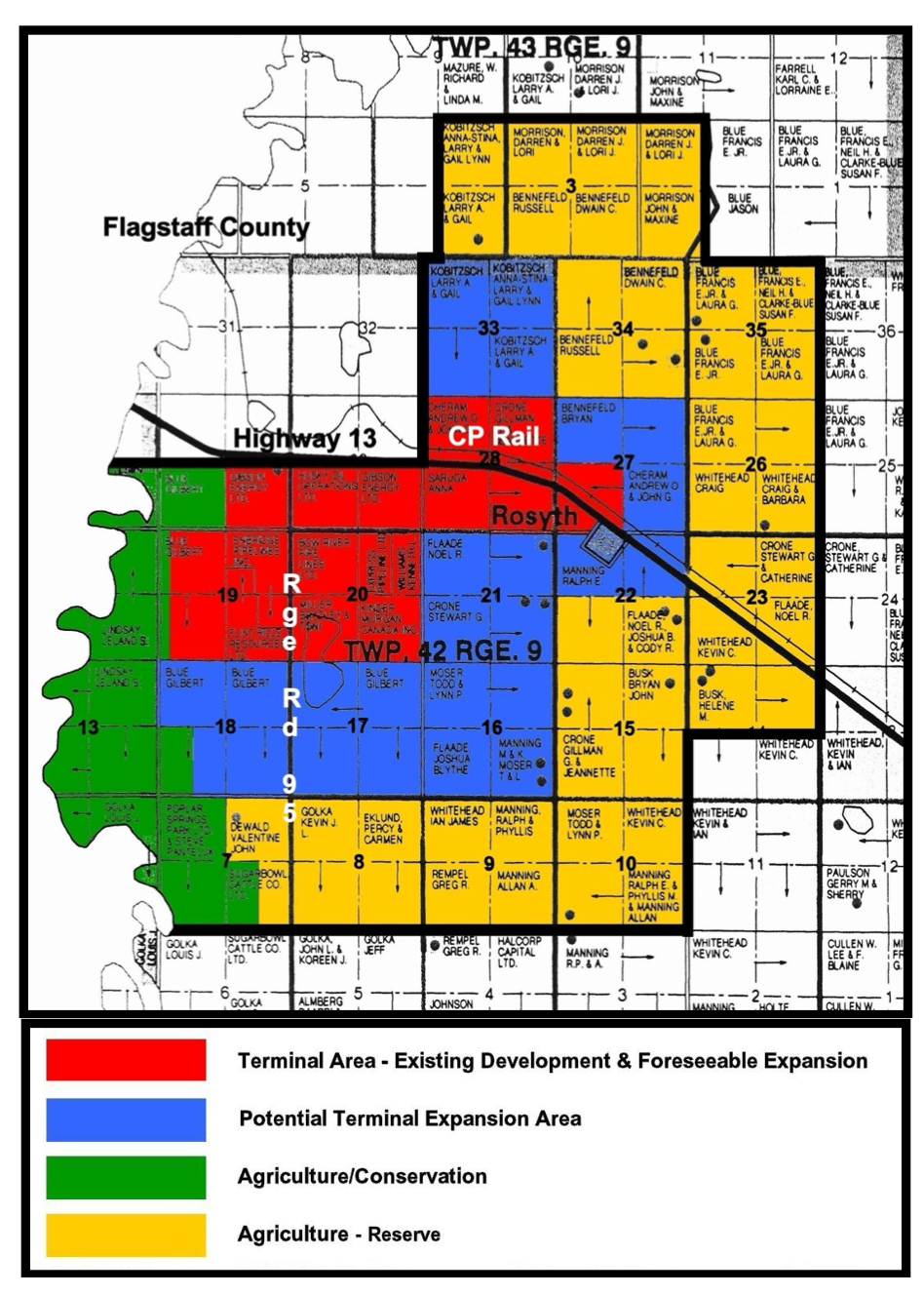
(3) Section 56.(3) applies to the lands within the “Terminal Area – Existing Development and Foreseeable Expansion” designation in Figure 2 on Page 7 of the Rosyth Area Structure Plan, being Bylaw 2200, and amendments thereto and shown under Subsection (2) of this district.
Permitted Uses Discretionary Uses
| Accessory building.
All uses and development over which the Municipal District has jurisdiction and lawfully in existence on parcels existing at the time this land use district was assigned and came into effect. Agricultural operation. Agricultural service facility. Contractor service, minor. Contractor service, major. Natural resource extraction. Natural resource processing. Outdoor storage. Owner-operator heavy vehicle and equipment storage/parking. Public utility. Temporary building. Temporary use. Transportation facilities. Warehouse. |
Accessory use.
Public utility building. Specialty agriculture. Work camp. Those uses which, in the opinion of the Development Authority or Subdivision Authority, are similar to the permitted or discretionary uses, and which conform to the general purpose and intent of this land use district and the Rosyth Area Structure Plan upon which it is based. |
(4) Section 56.(4) applies to the lands within the “Potential Terminal Expansion Area” designation in Figure 2 on Page 7 of the Rosyth Area Structure Plan, being Bylaw 2200, and amendments thereto and shown under Subsection (2) of this district.
Permitted Uses Discretionary Uses
| Accessory building.
All uses and development over which the Municipal District has jurisdiction and lawfully in existence on parcels existing at the time this land use district was assigned and came into effect. Agricultural operation. Agricultural service facility. Commercial storage. Contractor service, minor. Contractor service, major. Natural resource extraction. Natural resource processing. Outdoor storage. Owner-operator heavy vehicle and equipment storage/parking. Public utility. Temporary building. Temporary use. Transportation facilities. Warehouse. |
Accessory use.
Boarding/lodging. Home occupation, major. Home occupation, minor. Home office or studio. Public utility building. Recreation vehicle storage. Recycling depot. Recycling drop-off. Small animal boarding/breeding.
Specialty agriculture. Veterinary service. Work camp. Those uses which, in the opinion of the Development Authority or Subdivision Authority, are similar to the permitted or discretionary uses, and which conform to the general purpose and intent of this land use district and the Rosyth Area Structure Plan upon which it is based. |
(5) Section 56.(5) applies to the lands within the “Agriculture/Conservation” designation in Figure 2 on Page 7 of the Rosyth Area Structure Plan, being Bylaw 2200, and amendments thereto and shown under Subsection (2) of this district.
Permitted Uses Discretionary Uses
| Accessory building.
All uses and development over which the Municipal District has jurisdiction and lawfully in existence on parcels existing at the time this land use district was assigned and came into effect. Agricultural operation. Home office or studio. Public utility. Specialty agriculture. Temporary building. Temporary use. |
Accessory use.
Dwelling, double-wide manufactured. Dwelling, modular. Dwelling, single-wide manufactured. Dwelling, single detached. Natural resource extraction. Owner-operator heavy vehicle and equipment storage/parking. Public utility building. Those uses which, in the opinion of the Development Authority or Subdivision Authority, are similar to the permitted or discretionary uses, and which conform to the general purpose and intent of this land use district and the Rosyth Area Structure Plan upon which it is based. |
(6) Section 56.(6) applies to the lands within the “Agriculture – Reserve” designation in Figure 2 on Page 7 of the Rosyth Area Structure Plan, being Bylaw 2200, and amendments thereto and shown under Subsection (2) of this district.
Permitted Uses Discretionary Uses
| Accessory building.
All uses and development over which the Municipal District has jurisdiction and lawfully in existence on parcels existing at the time this land use district was assigned and came into effect. Agricultural operation. Bed and breakfast operation, minor. Boarding/lodging. Campground. Contractor service, minor. Extensive recreation. Home occupation, minor. Home office or studio. Natural resource extraction. Owner-operator heavy vehicle and equipment storage/parking. Public utility. Specialty agriculture. Temporary building. Temporary use. |
Accessory use.
Bed and breakfast operation, minor. Boarding/lodging. Campground. Contractor service, major. Dwelling, double-wide manufactured. Dwelling, modular. Dwelling, single-wide manufactured. Dwelling, single detached. Extensive recreation. Home occupation, major. Natural resource processing. Outdoor storage. Recreation vehicle storage. Recycling depot. Recycling drop-off. Public utility building. Small animal boarding/breeding. Surveillance suite. Veterinary service. Work camp. Those uses which, in the opinion of the Development Authority or Subdivision Authority, are similar to the permitted or discretionary uses, and which conform to the general purpose and intent of this land use district and the Rosyth Area Structure Plan upon which it is based. |
(7) Residential Development and Subdivision
(a) In accordance with the Rosyth ASP, for the lands within the “Terminal Area – Existing Development and Foreseeable Expansion and “Potential Terminal Expansion Area” designations, no dwellings shall be approved in addition to those which lawfully existed at the time the Rosyth ASP and this land use district came into effect shall be allowed. The only residential subdivision that will be considered shall be to encompass a dwelling lawfully in existence at the time the Rosyth ASP and this land use district came into effect. Note that such residential subdivision will not allow a dwelling to be developed on the remainder of the titled area being subdivided.
(b) In accordance with the Rosyth ASP, for the lands within the “Agriculture-Reserve” designation, one dwelling in addition to that which lawfully existed at the time the Rosyth ASP and this land use district came into effect shall be a discretionary use with any approval directing such development as far away as is reasonably possible away from the lands within the “Terminal Area – Existing Development and Foreseeable Expansion” and “Potential Terminal Expansion Area” designations. Residential subdivision shall be limited to a maximum of one residential lot per unsubdivided quarter section provided the subdivision encompasses a lawfully approved dwelling in existence prior to the residential subdivision application being accepted in its complete form (ie: no undeveloped residential lot/subdivision shall be allowed). Note that such residential subdivision would not necessarily allow a dwelling to be developed on the remainder of the titled area being subdivided. Notwithstanding any of the foregoing, no more than two dwellings shall be allowed to exist per quarter section within the “Agriculture-Reserve” designation.
(c) In accordance with the Rosyth ASP, for the lands within the “Agriculture/Conservation” designation, any dwelling lawfully in existence at the time the Rosyth ASP and this land use district came into effect shall be considered a permitted use meaning that it can be added to, rebuilt, replaced, etc. Where there is no dwelling present on a lot that existed at the time the Rosyth ASP and MDP/LUB amendments came into effect, the Development Authority may, on a discretionary basis, approve a dwelling taking into consideration the topography of the site, the provision of public road access to the dwelling and that such a dwelling should be sited as far away as is reasonably possible away from the lands within the “Terminal Area – Existing Development and Foreseeable Expansion” and “Potential Terminal Expansion Area” designations. Residential subdivision shall be limited to a maximum of one residential lot per unsubdivided quarter section provided the subdivision encompasses a lawfully approved dwelling in existence prior to the residential subdivision application being accepted in its complete form (ie: no undeveloped residential lot/subdivision shall be allowed). Note that such residential subdivision would not allow a dwelling to be developed on the remainder of the titled area being subdivided. Notwithstanding any of the foregoing, no more than one dwelling shall be allowed to exist per quarter within the “Agriculture-Conservation” designation.
(8) Minimum Site Area
Unless otherwise prescribed in this Bylaw, the minimum site area shall be as determined by the Subdivision or Development Authority, as the case may be, who shall take into account the general purpose and intent of this land use district, the location and setbacks of adjacent land uses and buildings as well as the other site provisions of this land use district.
(9) Minimum Setback Requirements
(a) Minimum front yard – the minimum front yard distance shall be 41.0 m (~134.5 ft) from the front yard property line.
(b) Minimum side and rear yard – the minimum side and rear yard distances shall be 15.0 m (~49.25 ft) from the side and rear yard property lines, respectively, except where the side or rear yard is adjacent to a road in which case the minimum distance shall be 41.0 m (~134.5 ft) from the side and rear yard property lines, respectively.
(10) Building Height
The height of a building shall be at the discretion of the Development Authority who shall take the following into account in determining height:
(a) The topography of the parcel upon which the building is or is to be situated as well as the topography of immediately adjacent parcels and the surrounding area shall be considered to ensure that the sight lines and view angles of the
subject parcel and adjacent parcel are not unduly obstructed by the height of the building.
(b) The height of a building shall be in proportion with the principal and accessory buildings on immediately adjacent parcels as well as in keeping with the surrounding area.
(c) The fire safety provisions of the Alberta Safety Codes Act and regulations thereto, as may be amended from time to time, and the capacity and availability of fire fighting equipment and personnel.
(11) Design, Character and Appearance of Buildings
The design, siting, external finish, architectural appearance and landscaping generally, of all buildings, including any accessory buildings or structures and signs, and any reconstruction, shall all be to the satisfaction of the Development Authority, so there is conformity with adjacent buildings, and adequate protection afforded to the amenities of adjacent properties. As a condition of a development permit, the Development Authority may require a letter of guarantee or an irrevocable letter of credit in order to secure compliance with any requirements imposed.
(12) Other Provisions
(a) No activity may be undertaken that would, in the opinion of the Development Authority, unduly interfere with the amenities or materially interfere with or affect the use, enjoyment or value of neighbouring properties by reason of excessive noise, smoke, steam, odour, glare, dust, vibration, refuse matter or other noxious emissions or containment of hazardous materials.
(b) To determine if the subject land is suitable for and can physically support/sustain the proposed use or development in question, the Development Authority may require, before accepting an application as complete, any geotechnical analysis or any other engineering, environmental or technical assessment/information it considers necessary to properly evaluate the application. The Development Authority will ensure that the analysis/assessment/information they require is prepared/substantiated by qualified persons licensed to practice in the Province of Alberta.
(c) To the level of detail determined by the Development Authority, applicants shall fully disclose the precise nature and extent of the proposed use, subdivision and/or development, including intended hours of operation, so that their applications can be thoroughly evaluated in accordance with this land use district.
(d) Upon receipt of a completed application, the Development Authority may, prior to making a decision, refer the application to any municipal department or any other external agency for comment and may require a Surveyor’s Certificate or Real Property Report, signed by an Alberta Land Surveyor, relating to any existing/proposed building or other improvement that is the subject of the application.
(e) The Development Authority may:
- i) as a condition of approval, require that the applicant enter into a development agreement with the Municipal District pursuant to the Municipal Government Act. To ensure compliance with the conditions in the agreement, the Municipal District may be protected by caveat registered in favour of the Municipal District;
- ii) as a condition of approval, require financial guarantees, in a form and an amount acceptable to the Municipal District, from the applicant to secure performance of any of the conditions of the approval; and/or,
iii) revoke an approval in the case where satisfactory arrangements have not been made by a developer for the supply of water, disposal of sewage and road access, or any of them.
(f) In the case of new construction, the Development Authority shall require, as a condition of approval, that a Surveyor’s Certificate or Real Property Report, signed by an Alberta Land Surveyor, relating to the building(s) that is (are) the subject of the development permit application, be submitted by the owner/developer upon completion of the building foundation and prior to commencement of framing or further structural construction to ensure that the building(s) is (are) sited according to the provisions of the development permit and any other relevant provisions of the Bylaw.
(g) The Development Authority may stipulate the times of the day or week during which an approved use or development may operate as well as the length of time its approval remains in effect.
(h) As a condition of approval, the Development Authority may require that an approved use or development be screened from public thoroughfares and adjacent residential uses by a solid wall, fence or other means in a manner and to a height satisfactory to them.
(i) The Development Authority may issue a temporary development permit where the Development Authority is of the opinion that the proposed use is of a temporary nature.
(j) Owner-operator heavy vehicle and equipment storage/parking – the following provisions shall apply:
- i) no heavy vehicles or equipment shall be stored or parked on-site other than those owned and operated by the resident landowner including any family members of the resident landowner also resident on-site.
- ii) all heavy vehicles or equipment stored/parked on-site shall be stored-parked outside and in a neat and orderly fashion.
iii) the development authority, at their discretion and to their satisfaction, may require that an area used for the outside storage/parking of heavy vehicles and equipment be screened from view.
(k) If an application involves explosives or radioactive material, the Development or Subdivision Authority, as the case may be, shall:
- i)consider the effects of the storage and/or transport of explosives or radioactive material proposed in an application (e.g. the implications of the development setbacks specified in the Quantity-Distance tables of the Explosives Regulations or the provisions of the Transportation of Dangerous Goods Act) on the other existing and proposed use(s) located or proposed to be located on the subject parcel as well as adjacent parcels;
- ii) at their discretion, prior to deciding upon the application before them, provide public notice, through means and to whom they consider necessary, that a decision regarding an application involving the storage and/or transport of explosives or radioactive material is to be made, that an opportunity will be afforded to any person notified to make representation on the application and that the representations made shall be taken into account when final consideration is given to the said application; and,
iii) based on the circumstances of the application before them, and at their sole discretion, either grant their approval, provided the application otherwise complies with this Plan or any conceptual scheme in effect, the Municipal Development Plan and the Land Use Bylaw, subject to the applicant complying with all applicable provincial and federal as well as any other municipal regulations related to explosives or radioactive material (and submitting proof of same – e.g. a license or certificate, as specified by the Development or Subdivision Authority, that they have complied), or withhold their approval until such time as the applicant demonstrates, to their satisfaction, compliance with all applicable provincial and federal as well as any other municipal regulations related to explosives or radioactive material.
(l) If at any time, in the opinion of Development Authority, any of the provisions of this land use district have not been complied with, the Development Authority may utilize the enforcement mechanisms available under the Municipal Government Act.
(m) Unless contrary to any provisions of this land use district or the Rosyth Area Structure Plan to which this land use district is tied, or if this land use district or the Rosyth Area Structure Plan to which this district is tied already specifies provisions, in which case, this land use district and the Rosyth Area Structure Plan to which this district is tied shall prevail, all other provisions in the Land Use Bylaw shall apply.
57. “CWE” – Commercial Wind Energy District
(1) Purpose
The purpose and intent of this district it to ensure that agricultural activities and other compatible land uses may continue while allowing flexibility to accommodate Wind Energy Conversion System development in accordance with the Municipal Development Plan and other relevant regulations and standards
(2) Permitted Uses:
Accessory Buildings and Uses
Detached Dwelling
Extensive Agriculture
Farmstead
Manufactured Home
Production of Honey
Production of Specialty Horticultural Crops
(3) Discretionary Uses
Agri-Tourism Operations
Animal Care Facilities
Bed and Breakfast Establishments
Commercial Uses
Confined Feeding Operations
Home Occupations
Industrial Uses
Institutional and Public Uses
MET Tower
Natural Resource Extractive Industries
Recreation Uses
Signs
Wind Energy Conversion System – Commercial in accordance with Section 40.17 and 40.18
Wind Energy Conversion System – Microgeneration in accordance with Section 40.15 and 40.16
(4) Minimum Requirements
(a) Site Area
(i) Agricultural land should be retained as large, intact parcels;
(ii) All other uses are at the discretion of the Development Authority.
(b) Front Yard
(i) As required by Alberta Transportation in the case of provincial highways;
(ii) 40 m (125 ft) from the centre line of municipal roads.
(c) Side Yard
(i) 7.5 m (25 ft);
(ii) Accessory buildings and shelter belts shall be at the discretion of the Development Authority.
(d) Rear Yard
(i) 7.5 m (25 ft);
(ii) Accessory buildings and shelter belts shall be at the discretion of the Development Authority.
(e) Setbacks and requirements for WECS in accordance with Section 40.15 – 18
(5) Subdivision
(a) Upon review of any subdivision application the subdivision authority shall take into consideration the relevant setbacks and requirements for any WECS applications in process, approved or developed in the district.
- The addition of the following land use:
Wind Energy Conversion System – Microgeneration in accordance with Section 40.15 and 40.16
as a discretionary use in the following land use districts:
- “AD” – Agricultural District
- “CR” – Country Residential District
- “RB/I” – Rural Business Industrial District
- “HM” – Hamlet Industrial District
- “HPI” – Hamlet Public / Institutional District
- “RSH” – Rural Small Holding District
- The addition of the following land use:
Meteorological (MET) Tower
as a discretionary use in the following land use districts:
- “AD” – Agricultural District
- “CWE” – Commercial Wind Energy District
- The addition of the following definition in Part I:
(38a) Meteorological (MET) Tower means a structure equipped with anemometers, wind vanes and and/or temperature, pressure and relative humidity sensors used to calculate meteorological data;
58. “CSE” – Commercial Solar Energy District
(1) Purpose
The purpose and intent of this district it to ensure that agricultural activities and other compatible land uses may continue while allowing flexibility to accommodate Commercial Solar Energy System development in accordance with the Municipal Development Plan and other relevant regulations and standards.
(2) Permitted Uses:
Accessory Buildings and Uses
Detached Dwelling
Extensive Agriculture
Farmstead
Manufactured Home
Production of Honey
Production of Specialty Horticultural Crops
(3) Discretionary Uses
Agri-Tourism Operations
Animal Care Facilities
Bed and Breakfast Establishments
Commercial Uses
Confined Feeding Operations
Home Occupations
Industrial Uses
Institutional and Public Uses
MET Tower
Natural Resource Extractive Industries
Recreation Uses
Signs
Solar Energy System – Microgeneration in accordance with Section 41.11 and 41.12
Solar Energy System – Commercial in accordance with Section 41.13 and 41.14
(4) Minimum Requirements
(a) Site Area
(i) Agricultural land should be retained as large, intact parcels;
(ii) All other uses are at the discretion of the Development Authority.
(b) Front Yard
(i) As required by Alberta Transportation in the case of provincial highways;
(ii) 40 m (125 ft) from the centre line of municipal roads.
(c) Side Yard
(i) 7.5 m (25 ft);
(ii) Accessory buildings and shelter belts shall be at the discretion of the Development Authority.
(d) Rear Yard
(i) 7.5 m (25 ft);
(ii) Accessory buildings and shelter belts shall be at the discretion of the Development Authority.
(e) Setbacks and requirements for SES in accordance with Section 41.11 – 14
(5) Subdivision
(a) Upon review of any subdivision application the subdivision authority shall take into consideration the relevant setbacks and requirements for any SES applications in process, approved or developed in the District.
- The addition of the following land use:
Solar Energy System – Microgeneration in accordance with Sections 41.11 and 41.12
as a discretionary use in the following land use districts:
- “AD” – Agricultural District
- “CR” – Country Residential District
- “RB/I” – Rural Business Industrial District
- “HM” – Hamlet Industrial District
- “HPI” – Hamlet Public / Institutional District
- “RSH” – Rural Small Holding District
PART VIII
Land Use District Maps
List of Maps
- Key Map
- Rosyth Area Map One
- Amisk Area Map Two
- Hughenden Map Three
- Shorncliffe Lake and Vicinity Map Four
- Czar Area Map Five
- Capt Eyre Lake Area Map Six
- Hamlet of Metiskow Map Seven
- Hamlet of Cadogan Map Eight
- Town of Provost Vicinity Area Map Nine
- Hamlet of Hayter Map Ten
- St. Lawrence Lake Area Map Eleven
- Hamlet of Bodo Map Twelve
- Airport Vicinity Protection Area Map Thirteen
APPENDICES
The following appendices do NOT form part of this Land Use Bylaw and are for reference and information only. APPENDIX “A”
INFORMATION REQUIREMENTS FOR INDUSTRIAL AND COMMERCIAL DEVELOPMENT PERMIT APPLICATIONS
In applying for a development permit for an industrial or commercial use, the applicant may be required to provide the Development Authority with the following information:
- location of proposed development
- type of industry / commercial use
- size of building(s)
- number of off-site employees
- estimated water demand and source
- type of effluent and treatment / disposal method(s)
- transportation routes to be used and estimated amount of traffic
- accessory services required
- environmental assessment of proposed site
- any other information deemed necessary by the Development Authority.
APPENDIX “B”
MINIMUM SPECIFICATIONS FOR
RESIDENTIAL DEVELOPMENT IN LAKE DISTRICTS
FOUNDATION To be of concrete, mortared brick, stone, treated wood, or cement block construction, either continuous footing or sufficient pillar support.
FLOOR JOISTS When floor joists are used, refer to the following table which indicates the maximum clear span for floor joists single bridging.
| Spruce | Fir | |||||||
| 12”o.c. | 16”o.c. | 20”o.c. | 24”o.c. | 12”o.c. | 16”o.c. | 20”o.c. | 24”o.c. | |
| 2×6 | 9’ 2” | 8’ | 7’ 1” | 6’ 6” | 11’ | 10’ | 9’ 4” | 8’ 8” |
| 2×8 | 13’ 4” | 12’ | 11’ 2” | 10’ 4” | 15’ | 13’ 7” | 12’ 8” | 11’ 11” |
| 2×10 | 16’ 10” | 15’ 2” | 14’ 2” | 13’ | 19’ | 17’ 4” | 16’ | 15’ 1” |
FLOOR SPACE A minimum of 300 square feet exclusive of verandah area.
WALL FRAMING Minimum studding – 2” x 4” x 8’ – 16”o.c.
ROOF Gable or cottage type only, unless permission is obtained from the Municipality to construct a building having a sloped or flat roof. To be finished with either asphalt or cedar shingles or metal roofing (rolled asphalt roofing on Municipally approved flat roof only).
CHIMNEY Either brick, cement block, selkirk, or such other type of chimney approved by the Municipality. To be 2’ from all woodwork for fire protection and prevention. Spark arrestors are to be installed.
DOORS Each cabin or cottage shall contain a front and rear entrance for reasons of health and fire protection unless the building is specifically designed where a side entrance only will suffice.
EXTERIOR FINISH To be of some recognized building siding, either manufactured wood material, metal, or asphalt. In the case of wood, product is to be painted or varnished.
PLANS One copy of the floor plan, on a proper application form, showing all dimensions must be filed with the Municipality, and construction must not start until the plan has been approved.
COSTS An estimated cost of the building must be given:
- Cost of Materials
2. Cost of Labour